Our Flooded Future: Global vulnerability to sea level rise worse than previously understood.
New elevation data show that by midcentury frequent coastal flooding will rise higher than areas currently home to hundreds of millions of people
EXECUTIVE SUMMARY
-
As a result of heat-trapping pollution from human activities, rising sea levels could within three decades push chronic floods higher than land currently home to 300 million people
-
By 2100, areas now home to 200 million people could fall permanently below the high tide line
-
The new figures are the result of an improved global elevation dataset produced by Climate Central using machine learning, and revealing that coastal elevations are significantly lower than previously understood across wide areas
-
The threat is concentrated in coastal Asia and could have profound economic and political consequences within the lifetimes of people alive today
-
Findings are documented in a new peer-reviewed paper in the journal Nature Communications
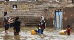
Sea level rise is one of the best known of climate change’s many dangers. As humanity pollutes the atmosphere with greenhouse gases, the planet warms. And as it does so, ice sheets and glaciers melt and warming sea water expands, increasing the volume of the world’s oceans. The consequences range from near-term increases in coastal flooding that can damage infrastructure and crops to the permanent displacement of coastal communities.
Over the course of the twenty-first century, global sea levels are projected to rise between about 2 and 7 feet, and possibly more. The key variables will be how much warming pollution humanity dumps into the atmosphere and how quickly the land-based ice sheets in Greenland and especially Antarctica destabilize. Projecting where and when that rise could translate into increased flooding and permanent inundation is profoundly important for coastal planning and for reckoning the costs of humanity’s emissions.
Projecting flood risk involves not only estimating future sea level rise but also comparing it against land elevations. However, sufficiently accurate elevation data are either unavailable or inaccessible to the public, or prohibitively expensive in most of the world outside the United States, Australia, and parts of Europe. This clouds understanding of where and when sea level rise could affect coastal communities in the most vulnerable parts of the world.
A new digital elevation model produced by Climate Central helps fill the gap. That model, CoastalDEM, shows that many of the world’s coastlines are far lower than has been generally known and that sea level rise could affect hundreds of millions of more people in the coming decades than previously understood.
Based on sea level projections for 2050, land currently home to 300 million people will fall below the elevation of an average annual coastal flood. By 2100, land now home to 200 million people could sit permanently below the high tide line.
Adaptive measures such as construction of levees and other defenses or relocation to higher ground could lessen these threats. In fact, based on CoastalDEM, roughly 110 million people currently live on land below high tide line. This population is almost certainly protected to some degree by existing coastal defenses, which may or may not be adequate for future sea levels.
Despite these existing defenses, increasing ocean flooding, permanent submergence, and coastal defense costs are likely to deliver profound humanitarian, economic, and political consequences. This will happen not just in the distant future, but also within the lifetimes of most people alive today.
GROUND TRUTH
Scientists have long worked to project how quickly various amounts of global warming could raise the level of the world’s oceans—a question about which much uncertainty remains, given the challenges of understanding how ice sheets will respond to the extreme pace of warming they are now experiencing. Yet as researchers have labored over sea level rise models, another factor critical to understanding the world’s vulnerability to rising waters has been largely overlooked. That factor is coastal elevation. In the absence of coastal defenses such as levees, elevation determines the extent to which ocean floods can wash over the land.

Accurately measuring coastal elevation over large areas is neither easy nor cheap. Some countries, such as the United States, use a remote-sensing technology called lidar to reliably map the heights of their coastlines, and publicly release the results. Lidar is relatively expensive, however, typically requiring plane, helicopter, or drone overflights, as well as laser-based equipment. Where lidar data are not available, researchers and analysts rely on one of several global datasets, most typically data sensed from Earth’s orbit through a NASA project known as the Shuttle Radar Topography Mission, or SRTM.
Although SRTM data are freely available online, they are less reliable than lidar. SRTM data measure the tops of features that protrude from the ground—such as buildings and trees—as well as the ground itself. As a result, SRTM data generally overestimate elevation, particularly in densely forested and built-up areas. In low-lying parts of coastal Australia, for instance, SRTM data overestimate elevation by an average of 8.2 feet (2.5 meters). Globally, the average overestimate appears to be roughly six feet (two meters). These values match or exceed most of the highest sea level rise projections for the entire century.
In coastal regions, overestimates of elevation produce underestimates of future inundation driven by sea level rise. Understanding the real threat posed by future sea level rise requires a better view of the ground beneath our feet.
That is the purpose of CoastalDEM. Developed using machine learning working with more than 51 million data samples (see methodology), the new dataset is substantially more accurate than SRTM, particularly in densely populated areas—precisely those places where the most people and structures are threatened by rising seas. In low-elevation coastal areas in the United States with population densities over 50,000 people per square mile, such as parts of Boston, Miami, and New York City, SRTM overestimates elevation by 15.5 feet on average. CoastalDEM cuts the average error to less than 2.5 inches.
Combining CoastalDEM with sea-level-rise and coastal-flood models produces new estimates of exposure to rising seas around the world (box 2). Those estimates reveal that far more land—and more people—will be vulnerable to sea level rise during this century than previously believed (chart 1). In fact, using CoastalDEM’s improved data on coastal elevation makes a bigger difference in projected exposure to ocean flooding than does switching from a low-end to a high-end sea-level-rise scenario when SRTM data are used.
THREE DECADES FROM TODAY
Sea level rise is a global story, and it affects every coastal nation. But in the coming decades, the greatest effects will be felt in Asia, thanks to the number of people living in the continent’s low-lying coastal areas. Mainland China, Bangladesh, India, Vietnam, Indonesia, and Thailand are home to the most people on land projected to be below average annual coastal flood levels by 2050 (table 2). Together, those six nations account for roughly 75 percent of the 300 million people on land facing the same vulnerability at midcentury.
Box 3 (below) details caveats and limitations for this report’s findings.
Chart 1. Current population below the elevation of an average annual flood in 2050, top six countries
Moderate emissions cuts
| Country | SRTM | CoastalDEM | Change |
| 1. China (mainland) | 29 million people | 93 million people | +67 million people |
| 2. Bangladesh | 5 million people | 42 million people | +37 million people |
| 3. India | 5 million people | 36 million people | +31 million people |
| 4. Vietnam | 9 million people | 31 million people | +22 million people |
| 5. Indonesia | 5 million people | 23 million people | +18 million people |
| 6. Thailand | 1 million people | 12 million people | +11 million people |
| Total, global | 79 million people | 300 million people | +221 million people |
| Moderate emissions cuts (RCP 4.5), Kopp et al. 2014, median climate sensitivity. Population exposure estimates do not factor in potential coastal defenses, such as seawalls or levees. |
A closer look at the cases of mainland China, India, Bangladesh, and Vietnam sheds light on the scope of the problem.
Start with mainland China. By 2050, land now home to 93 million people could be lower than the height of the local average annual coastal flood. Shanghai, which is the country’s most populous city, is projected to be particularly vulnerable to ocean flooding in the absence of coastal defenses (box 4). Low-lying Jiangsu Province, which abuts Shanghai, is also vulnerable. So are Tianjin, the main port for the capital city of Beijing, and the Pearl River Delta region, an urban agglomeration comprising several major mainland cities and the special administrative regions of Hong Kong and Macau (explore map at coastal.climatecentral.org).
Box 4. Future coastal flood threats in Shanghai, China
Home to 26 million people, Shanghai is China’s biggest single urban agglomeration. The city is the world’s busiest container port and mainland China’s top financial center.
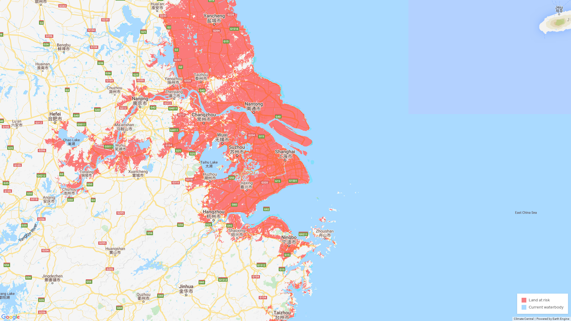
Annual flood threat zone, 2050
*Maps do not factor in potential coastal defenses, such as seawalls or levees, and are based on elevation, rather than flood models. Emissions pathway: moderate emissions cuts (RCP 4.5) roughly consistent with the Paris climate agreement’s two-degree target. Sea level rise model: Kopp et al. 2014, median climate sensitivity. Elevation model: CoastalDEM.
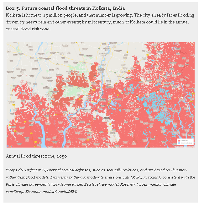
Next, consider India’s situation in 2050. By that year, projected sea level rise could push average annual floods above land currently home to some 36 million people. West Bengal and coastal Odisha are projected to be particularly vulnerable, as is the eastern city of Kolkata (box 5; explore map at coastal.climatecentral.org).
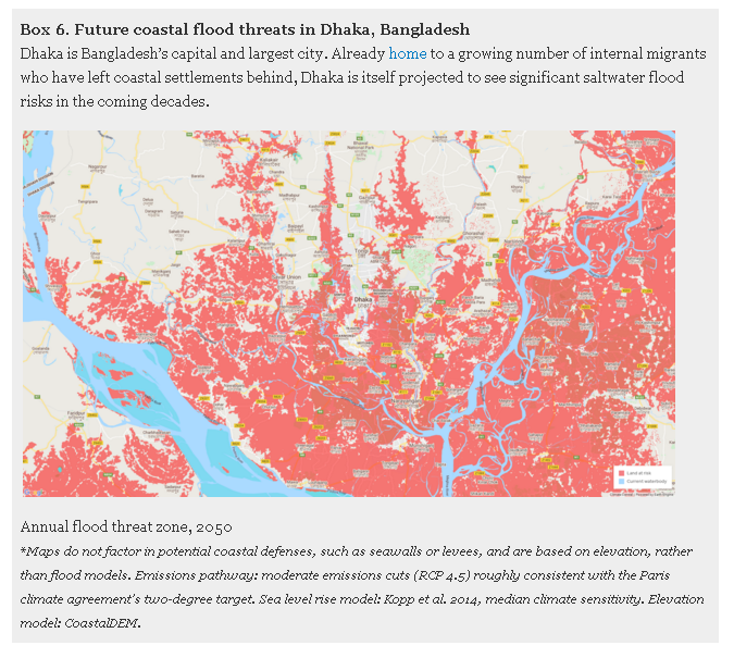
Finally, take Bangladesh and Vietnam, where coastal land currently home to 42 million and 31 million people, respectively, could be threatened with saltwater flooding at least once per year at midcentury. By that time, average annual coastal floods are projected to rise higher than a wide swath of Bangladesh, including parts of the cities of Dhaka and Chittagong (box 6; explore map at coastal.climatecentral.org). In Vietnam, annual ocean floods are projected to particularly affect the densely populated Mekong Delta and the northern coast around Vietnam’s capital, Hanoi, including the port city of Haiphong (explore map at coastal.climatecentral.org).
PERMANENT LOSSES
As sea levels continue to rise throughout the century, chronic flooding will spread and more land will be permanently lost to the ocean. By 2100, CoastalDEM’s elevation data show, land currently home to 200 million people could fall permanently below the high tide line.
The bad news is again concentrated in Asia. China, Bangladesh, India, Vietnam, Indonesia, and Thailand are home to the greatest number of people who today live on land that could be threatened by permanent inundation by 2100—151 million in total, and 43 million in China alone.
But the danger of permanent inundation is by no means be limited to Asia. In 19 countries, from Nigeria and Brazil to Egypt and the United Kingdom, land now home to at least one million people could fall permanently below the high tide line at the end of the century and become permanently inundated, in the absence of coastal defenses.
The residents of small island states could face particularly devastating losses. Three of every four people in the Marshall Islands now live on land that could lie below high tide in the next eighty years. In the Maldives, the figure is one in three. And well before that land is flooded, residents will face saltwater intrusion into freshwater supplies and frequent flooding. In small islands states, as elsewhere, land could become uninhabitable well before it disappears.
Even as land home to 200 million people today will be threatened by permanent inundation, areas now home to an additional 360 million will face the threat of at-least annual floods, totalling more than half-a-billion people on highly vulnerable land. Under a higher-emissions scenario, and near the tail end (95th percentile) of sea-level rise sensitivity to warming for the model used in this study, land home to 640 million people today—approaching 10 percent of the world’s population—could be threatened by the end of the century, either by chronic flooding or permanent inundation.
AN INHUMAN TOLL
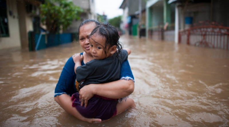
Projecting the specific economic, humanitarian, and political costs of the upward revision in global exposure to sea level rise revealed by CoastalDEM is beyond the scope of this report. But the evidence suggests that those costs will be steep. In the decades ahead, sea level rise could disrupt economies and trigger humanitarian crises around the world.
Estimates of future economic losses from sea level rise vary depending on the amount of climate pollution and subsequent rise projected, as well as other factors, such as whether future population growth, innovation, or migration are considered. Some projections indicate that flooding could cause tens of trillions of dollars in losses each year by the end of the century—or trillions per year, if extensive adaptation measures are implemented. In practice, the costs will run deeper than immediate physical damage to buildings and infrastructure, or the costs of adaptation, which will never be perfect. Flooding can be costly because it can displace productive local economies dependent on density and convenient coastal locations. It could also disrupt global supply chains by limiting access to ports and coastal transportation.
Take the case of the coastal provinces of China, the country that today is home to more people who live on land vulnerable to chronic flooding at midcentury than any other. In recent decades, China’s coastal provinces have attracted millions of migrants from the country’s interior and have become important centers in the global economy. Jiangsu Province, China’s most densely populated province, could be highly vulnerable to chronic ocean flooding in just thirty years. The same is true of Guangdong Province, another coastal economic powerhouse (explore map at coastal.climatecentral.org). Economic losses in China would matter for the rest of the world: the country is responsible for more than a quarter of the growth in today’s global economy and is projected to remain the world’s biggest economy, in purchasing power parity terms, in 2050.
Sea level rise could also produce humanitarian crises by stripping millions of people of their homes and traditional livelihoods. The developing countries least able to protect their residents through coastal defenses or planned evacuations could be particularly vulnerable—and are responsible for just a small fraction of global emissions.
In Bangladesh, where per-capita emissions and per-capita GDP are more than thirty times lower than in the United States, flooding-driven displacement is not just a future prospect; it has already arrived. CoastalDEM data show that the problem is set to worsen. Today, one in every four Bangladeshis lives on land that could flood at least once a year, on average, by 2050. (Even the country’s most infamous refugee crisis could be exacerbated by sea level rise: in recent years, hundreds of thousands of Rohingya people have fled violence in neighboring Myanmar, many settling in the low-lying region south of Chittagong—an area that could itself be vulnerable to at-least-annual ocean flooding by 2050, projections based on CoastalDEM show.)
Sea level rise could have wide-ranging political consequences. Coastal displacement could shrink local tax bases, straining municipalities’ abilities to pay for public goods such as education. The retreat of the world’s coasts could affect countries’ near-shore maritime claims, encouraging international disputes over fisheries and other ocean resources. And in states around the world, mass displacement could shape national politics. The recent migration that has figured so prominently in recent European elections pales in comparison to the potential displacements of the coming decades, when many millions of people could flee rising seas around the world—both across borders, and within them. Drought, extreme heat, and the other dangers of climate change could displace many more.
Deep, immediate cuts to global emissions would modestly reduce the danger posed by rising seas this century. Such cuts would reduce the total number of people threatened by annual flooding and permanent inundation at the end of the century by 20 million, relative to moderate emissions cuts made roughly in line with the Paris agreement. Notably, the benefits of deep emissions cuts would reach far beyond sea level rise, reducing the danger posed by climate change’s many other risks. If governments seek to limit future impacts from ocean flooding, they could also avoid new construction in areas at high risk of inundation, while protecting, relocating, or abandoning existing infrastructure and settlements. Sea level rise is a near term danger: today’s communities must make choices not just on the behalf of future generations, but also for themselves.
Methodology: CoastalDEM (Kulp and Strauss 2018) is a new digital elevation model based onSRTM 3.0, a near-global dataset derived from satellite radar during a NASA mission in 2000. SRTM is known to contain significant error caused by factors such as topology, vegetation, buildings, and random noise. Climate Central used machine learning techniques to estimate SRTM elevation error in coastal areas between (and including) 1 and 20 meters (3.3 and 65.6 feet) in nominal SRTM elevation. Each pixel in CoastalDEM represents the corrected elevation at that point — the result of subtracting estimated error from SRTM 3.0.
Climate Central converted elevation data to reference local mean higher-high water levels (roughly, high tide lines, derived using satellite measurements of sea surface heights and using global tidal models), and compared these elevations to sea level rise projections (Kopp et al. 2014) to find regions that could permanently fall under the new high tide line in the coming decades. Separately, Climate Central added in local flood risk statistics approximating the one-year return level (approximately annual) water height (Muis et al. 2016), allowing the analysis to combine the water heights of such flood events with projected sea level rise when identifying areas at high risk.
Climate Central then added up populations (Landscan 2010) within the identified areas to compute how many people today live on implicated land. This process was repeated for a number of different years and sea level rise model sensitivities, and under low, moderate, and high emissions pathways for heat-trapping pollution (Representative Concentration Pathways 2.6, 4.5, and 8.5), in order to achieve a comprehensive assessment of global coastal vulnerability.
For more details, see Kulp and Strauss 2019, published in Nature Communications. It is the peer-reviewed scientific paper upon which this report is based.
Footnotes:
1. Bakker, A. M. R., Wong, T. E., Ruckert, K. L. & Keller, K. Sea-level projections representing the deeply uncertain contribution of the West Antarctic ice sheet. Scientific Reports 7, 3880 (2017).
Dangendorf, S. et al. Reassessment of 20th century global mean sea level rise. Proceedings of the National Academy of Sciences 114, 5946– 5951 (2017).
Kopp, R. E. et al. Probabilistic 21st and 22nd century sea-level projections at a global network of tide-gauge sites. Earth’s Future 2, 383–406 (2014).
Kopp, R. E. et al. Evolving Understanding of Antarctic Ice-Sheet Physics and Ambiguity in Probabilistic Sea-Level Projections. Earth’s Future 5, 1217–1233 (2017).
Nauels, A., Meinshausen, M., Mengel, M., Lorbacher, K. & Wigley, T. M. L. Synthesizing long-term sea level rise projections the MAGICC sea level model v2.0. Geoscientific Model Development 10, 2495–2524 (2017).
Wong, T. E., Bakker, A. M. & Keller, K. Impacts of Antarctic fast dynamics on sea- level projections and coastal flood defense. Climatic Change 144, 347–364 (2017).
Jevrejeva, S., Moore, J. & Grinsted, A. Sea level projections to AD2500 with a new generation of climate change scenarios. Global and Planetary Change (2012).
Stocker, T. et al. Climate Change 2013: The Physical Science basis. Contribution of Working Group I to the Fifth Assessment Report of the Intergovernmental Panel on Climate Change (Cambridge University Press, Cambridge, United Kingdom and New York, NY, USA, 2013).
Le Bars, D., Drijfhout, S. & de Vries, H. A high-end sea level rise probabilistic projection including rapid Antarctic ice sheet mass loss. Environmental Research Letters 12, 044013 (2017).
Jackson, L. P. & Jevrejeva, S. A probabilistic approach to 21st century regional sea-level projections using RCP and High-end scenarios. Global and Planetary Change 146, 179–189 (2016).
Nauels, A., Rogelj, J., Schleussner, C.-F., Meinshausen, M. & Mengel, M. Linking sea level rise and socioeconomic indicators under the Shared Socioeconomic Pathways. Environmental Research Letters 12, 114002 (2017).
Bamber, J., et al. Ice sheet contributions to future sea-level rise from structured expert judgment. Proceedings of the National Academy of Sciences, May 2019, 201817205; DOI:10.1073/pnas.1817205116
2. Kulp, S. A & Strauss, B.H. New elevation data triple estimates of global vulnerability to sea-level rise and coastal flooding. Nature Communications, October 2019, DOI: 10.1038/s41467-019-12808-z
3. Tighe, M. & Chamberlain, D. Accuracy Comparison of the SRTM, ASTER, NED, NEXTMAP USA Digital Terrain Model over Several USA Study Sites DEMs. In Proceedings of the ASPRS/MAPPS 2009 Fall Conference 351 (2009).
LaLonde, T., Shortridge, A. & Messina, J. The Influence of Land Cover on Shuttle Radar Topogra-phy Mission (SRTM) Elevations in Low Relief Areas. Transactions in GIS 14, 461–479 (2010).
Shortridge, A. & Messina, J. Spatial structure and landscape associations of SRTM error. Remote Sensing of Environment 115, 1576–1587 (2011). URL http://www.sciencedirect.com/science/article/pii/S0034425711000678.
Becek, K. Assessing Global Digital Elevation Models Using the Runway Method: The Advanced Spaceborne Thermal Emission and Reflection Radiometer Versus the Shuttle Radar Topography Mission Case. IEEE Transactions on Geoscience and Remote Sensing 52, 4823–4831 (2014). URL http://ieeexplore.ieee.org/articleDetails.jsp?arnumber=6651798.
4. Kulp, S. A. & Strauss, B. H. CoastalDEM: A global coastal digital elevation model improved from SRTM using a neural network. Remote Sensing of Environment 206, 231–239 (2018). URL https://www.sciencedirect.com/science/article/pii/S0034425717306016.
5. Kulp, S. A & Strauss, B.H. New elevation data triple estimates of global vulnerability to sea-level rise and coastal flooding. Nature Communications, October 2019, DOI: 10.1038/s41467-019-12808-z
6. Kulp, S. A & Strauss, B.H. New elevation data triple estimates of global vulnerability to sea-level rise and coastal flooding. Nature Communications, October 2019, DOI: 10.1038/s41467-019-12808-z
7. United Nations, Department of Economic and Social Affairs, Population Division (2018). World Urbanization Prospects: The 2018 Revision, custom data acquired via website.
8. Bright, E. A., Coleman, P. R., Rose, A. N. & Urban, M. L. Landscan 2010 (2011).
9. Kopp, R. E., DeConto, R. M., Bader, D. A., Hay, C. C., Horton, R. M., Kulp, S., Oppenheimer, M., Pollard, D., & Strauss, B. H. (2017). “Evolving Understanding of Antarctic Ice-Sheet Physics and Ambiguity in Probabilistic Sea-Level Projections,” Earth’s Future, 5, 1217–1233, https://doi.org/10.1002/ 2017EF000663
Jonathan L. Bamber, Michael Oppenheimer, Robert E. Kopp, Willy P. Aspinall, Roger M. Cooke. “Ice sheet contributions to future sea-level rise from structured expert judgment.” Proceedings of the National Academy of Sciences, May 2019, 201817205; DOI:10.1073/pnas.1817205116
Wong, T. E., Bakker, A. M. R., & Keller, K. (2017). Impacts of Antarctic fast dynamics on sea-level projections and coastal flood defense. Climatic Change, 144(2), 347–364.http://doi.org/10.1007/s10584-017-2039-4
Bakker, A. M. R., Wong, T. E., Ruckert, K. L., & Keller, K. (2017). Sea-level projections representing the deeply uncertain contribution of the West Antarctic ice sheet.Scientific Reports, 7(1), 3880. http://doi.org/10.1038/s41598-017-04134-5
Le Bars, D., Drijfhout, S., & de Vries, H. (2017). A high-end sea level rise probabilistic projection including rapid Antarctic ice sheet mass loss. Environmental Research Letters, 12(4), 044013. http://doi.org/10.1088/1748-9326/aa6512
10. Kopp, R. E., R. M. Horton, C. M. Little, J. X. Mitrovica, M. Oppenheimer, D. J. Rasmussen, B. H. Strauss, and C. Tebaldi (2014). Probabilistic 21st and 22nd century sea-level projections at a global network of tide-gauge sites. Earth’s Future, 2, 383–406, doi:10.1002/2014EF000239
11. Muis, S. et al. A global reanalysis of storm surges and extreme sea levels. Nat. Commun. 7:11969 doi: 10.1038/ncomms11969 (2016).
12. Claudia Tebaldi et al 2012 Environ. Res. Lett. 7 014032 https://iopscience.iop.org/article/10.1088/1748-9326/7/1/014032/meta; Buchanan, M.K., Kopp, R.E., Oppenheimer, M. et al., Climatic Change (2016) 137: 347. https://doi.org/10.1007/s10584-016-1664-7
Maya K Buchanan et al 2017 Environ. Res. Lett. 12 064009 https://iopscience.iop.org/article/10.1088/1748-9326/aa6cb3/meta
13. United Nations, Department of Economic and Social Affairs, Population Division (2018). World Urbanization Prospects: The 2018 Revision, custom data acquired via website.
14. United Nations, Department of Economic and Social Affairs, Population Division (2018). World Urbanization Prospects: The 2018 Revision, custom data acquired via website.
15. Desmet, Klaus & Kopp, Robert & Kulp, Scott A. & Nagy, Dávid Krisztián & Oppenheimer, Michael & Rossi-Hansberg, Esteban & Strauss, Benjamin H., 2018. “Evaluating the Economic Cost of Coastal Flooding,” CEPR Discussion Papers 13128, C.E.P.R. Discussion Papers.
16. National Bureau of Statistics of China, National Data, custom information acquired via website. http://data.stats.gov.cn/english/
17. Sefrioui S. (2017) Adapting to Sea Level Rise: A Law of the Sea Perspective. In: Andreone G. (eds) The Future of the Law of the Sea. Springer, Cham. https://doi.org/10.1007/978-3-319-51274-7_1
18. Bright, E. A., Coleman, P. R., Rose, A. N. & Urban, M. L. Landscan 2010 (2011).
- Posted in Oceans & Coasts, Sea Level, Society, Projections, Research
29 October 2019
CLIMATE CENTRAL