Can Shoreline Restoration Rein in Rising Flood Insurance Prices?
A pilot program on Dauphin Island, Alabama, aims to find out.
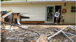
Some have called Alabama’s Dauphin Island the “Unluckiest Island in America” because it has repeatedly been hit by major hurricanes and storms. But it’s also a place where the residents have tremendous resilience and community strength, Terry Sheffield said, to rebuild after those storms.
“It’s amazing how well this community gets together and rebounds and repairs, and everybody helps everybody out,” said Sheffield, who is the town building inspector and has lived on the island since 2018.
Rebuilding comes with big expenses, however, and most homeowners on Dauphin Island can’t do it without home and flood insurance.
“Where it rains it floods, and the research has shown repeatedly that people who have insurance come back faster,” said Renee Collini, the director of the Water Institute’s Community Resilience Center.
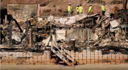
As climate change accelerates sea level rise and increases the intensity of tropical storms, insurance companies are beginning to re-evaluate whether they can afford to insure buildings that are expected to be damaged over and over again.
In some cases, this leads to skyrocketing insurance premiums, which Sheffield said many Dauphin Island residents have experienced. In other cases, insurance companies are leaving vulnerable markets entirely, including other communities on the Gulf of Mexico.
Restoring natural shorelines and coastal ecosystems is considered one of the best ways to lessen the damage from hurricanes and storm surges. Collini is now trying to figure out whether the benefits of those natural shorelines can be translated into insurance savings for Dauphin Island’s homes.
Graveline Bay: A Case Study
Graveline Bay is located on the eastern end of Dauphin Island, which is wider and therefore somewhat less vulnerable to flooding than the narrow spit of the west end. Still, the loss of coastal marsh habitats has made homes near the bay more susceptible to storm damage.
The Town of Dauphin Island contracted the firm Moffatt & Nichol, which has done a number of shoreline restoration projects, to rebuild the coastal marshes that once bordered Graveline Bay.
Like many projects funded by the settlement from the Deepwater Horizon oil spill (through the National Fish and Wildlife Foundation Gulf Environmental Benefit Fund), the Graveline Bay project included extensive measuring and modeling of tides and water levels in the bay both before and after the marsh restoration.
In that data, Collini saw an opportunity to quantify exactly how the newly rebuilt marsh impacted flooding of nearby homes.
Collini’s past work has focused on what prevents people and communities from becoming more resilient to floods and other natural disasters. She knew hard data could potentially convince private insurers and the federal National Flood Insurance Program (NFIP) that the homes near the new marsh now had a lower risk level, which could translate to lower premiums.
“We want to make sure we get credit for the flood risk benefits,” Collini said, even if the primary goal of the project was habitat restoration.
Since the marsh is small, Collini said the potential premium discount would be modest, akin to renovation projects that make a home more storm-resilient. Still, “as much as everything’s going up in price, every little bit helps,” she said.
And if this model works, she said, it can be applied to other shoreline restoration projects and amplify the impact on insurance affordability.
“This is considered to be a pilot project. This is the first time, or one of the first times, that someone has tried to calculate these benefits and translate them into insurance savings,” said Christina Mohrman, the director of strategic planning and partnerships for the Gulf of America Alliance, which provided funding for Collini’s work.
Moffatt & Nichol finished the Graveline Bay project in September 2023, though monitoring of the site is still ongoing with the help of the Dauphin Island Sea Lab and Alabama Audubon.
Collini is now in the midst of providing data to around 40 nearby homeowners and explaining how to share it with their insurers. She’s hoping within a few months to see whether the insurance discounts become a reality.
What’s Eating Dauphin Island
Dauphin Island is in a constant state of change. Mapping over decades has shown the island is narrowing and drifting westward due to the constant pressure of tidal erosion and sand movement.
The east end has lost 100 feet of shoreline in the last three decades, according to a report by the Yale School of the Environment. Since 1975, the narrow west end has eroded at a rate of 3 feet or more per year, according to the Dauphin Island Watershed Management Plan.
Some properties have been completely and permanently submerged.
That’s typical for a barrier island, especially one as narrow as Dauphin Island. But when there are homes and businesses located there, you can’t simply leave the island to the natural course of wind and tides.
Dauphin Island has been directly hit by four major hurricanes in the last century, the most recent being Sally and Zeta in 2020. Other hurricanes that didn’t make landfall there still caused significant damage, as with Katrina in 2005. According to the island’s watershed management plan, more than 80 tropical and subtropical cyclones have affected the Alabama coast since 1951.
Hurricanes Sally and Zeta caused an estimated $3.4 million in damages on Dauphin Island.
“We’re a barrier island. We take the brunt of anything that’s bad and hopefully we slow it down for everyone else,” Sheffield said.
Even seasonal tides and regular storms on the island can create surges or overload stormwater drainage, leading to flooded and damaged buildings, roads covered with sand and debris and more shoreline erosion. These smaller “nuisance floods” can slowly add up to significant damage costs.
“Our spring tides, they’re kind of like storm surges,” Sheffield said.
The Federal Emergency Management Agency (FEMA) considers Dauphin Island to have a “relatively high” risk of floods leading to property loss, according to its Flood Index.
The island is also feeling the effects of rising seas. According to NOAA, the sea level on Dauphin Island has risen about 1.35 feet in the past 100 years. It’s predicted to rise at least another foot by 2050, according to the 2023 National Climate Assessment.
Rising seas mean that each storm surge has the potential to reach higher peaks and travel further inland than it once did, and flood waters will also be slower to recede. Climate Central’s Coastal Risk Finder predicts a 2-foot annual flood on the island by 2030 and a 2.5-foot annual flood by 2050. A 100-year flood would bring 8 feet of water onto the island in 2050, based on current models.
The development of Dauphin Island has also destroyed some of its best defenses. While the town now has stricter building codes to protect marshes, dunes and other sensitive habitats, historical development often occurred on top of those ecosystems by owners seeking waterfront living.
“Everybody wants to have waterfront property, and that waterfront property comes at the expense of these marshes,” said Roberta Swann, the director of the Mobile Bay National Estuary Program.
Graveline Bay, for instance, has lost 75 acres of marshland over the last century or so, according to Moffatt & Nichol.
Wetlands are some of the fastest-disappearing habitats in the world. Trapped between homes and a rising tide, the remnants of Dauphin Island’s marshes are gradually slipping beneath the waves.
“As sea levels rise, there’s nowhere for those marshes to migrate to,” Swann said. “… Our marshes are drowning.”
Repetitive Losses
Homeowners on Dauphin Island and other communities in flood zones need insurance for flood damage in addition to their regular home insurance, since most home policies cover wind damage but not flooding. Those residents can choose a private flood policy or go through the National Flood Insurance Program, which provides coverage even in markets that private insurers consider too risky.
NFIP policies and premiums are determined by the age of a home, the flood zone it’s located in and its elevation. Flood insurance is optional in the low-risk flood zone, but it’s required in the high-risk zones if the owner wants a mortgage or loan for their property.
After severe storms or chronic floods, owners of damaged homes can submit a claim to the NFIP for the cost of needed repairs, just like typical home insurance.
Around 1,700 Dauphin Island properties are insured through the NFIP, according to the island’s watershed management plan. The NFIP insures 4.6 million homes across the country.
Communities that participate in the NFIP are required to enforce certain flood management rules, like requiring permits for development in some flood zones or using specific flood-resistant building materials. Dauphin Island created its flood damage prevention ordinance during the town’s incorporation in 1989.
According to FEMA, Dauphin Island homes built before the NFIP standards have post-storm insurance claims that average around four times higher than homes built since the town adopted the NFIP rules.
The NFIP also has a Community Rating System program, which discounts insurance for buildings that meet higher criteria than the NFIP minimum standards for storm and flood protection, such as elevating a home or putting on a wind-resistant roof.
Sheffield said the town has participated in the CRS program for many years because of its potential insurance savings. The discounts can vary between 5 and 45 percent, depending on the community’s Class Rating and the standards an individual home meets, according to FEMA.
“Any time we can get a participating house built out of harm’s way—storm surges in particular—we’re just going to save loss of life and loss of property,” Sheffield said.
He said most of the buildings on Dauphin Island are meeting at least some of the higher CRS standards.
Since 2018, new homes on the island are required to have roofs that meet the Gold Fortified Standard, meaning they can withstand 200-mile-per-hour hurricane winds.
The Alabama Department of Insurance provides some grant funding for homeowners to replace their roofs to meet the Fortified Roof or Silver Standards, which are lower than the Gold Standard, and the state mandates wind insurance discounts for homes that meet those discounts.
The state has awarded more than $86 million in grants for roof fortification and retrofitting so far. Collini called that funding program a “phenomenal system.”
During 2020’s Hurricane Sally, Collini said wind damage was less than expected in Alabama because of efforts to meet the higher standards. Sheffield said the elevated homes with Gold Standard roofs on the island didn’t receive damage during that storm, though older homes and town infrastructure still took a significant hit.
“There was less damage in Alabama because the overall pool was less risky,” Collini said.
A study released by the state’s Department of Insurance in May found that homes with roofs that met one of the Fortified standards were 55 percent to 74 percent less likely to file an insurance claim after Hurricane Sally. The severity of their losses was also lessened.
The study estimated that if every Alabama home impacted by Sally had a Fortified roof, insurers could have saved around $100 million in claim payouts.
Many homes on Dauphin Island are considered “repetitive loss” properties, meaning that they have had two separate flood insurance claims within a decade. A “severe repetitive loss” property has made four or more claims totaling more than $20,000, with at least two happening within a decade of each other.
There are more than 800 repetitive loss structures on Dauphin Island, plus nearly 70 that are considered severe repetitive loss, according to the watershed management plan.
The Yale School for the Environment reports that half of the island’s NFIP insurance claims have been made by only about 100 homes, with a few homes making claims more than 10 times. Dauphin Island has received more than $100 million in FEMA insurance payouts due to storm and flood damage, though exact records aren’t available.
Between 1988 and 2012, Dauphin Island property owners received nearly eight times as much money from the NFIP as they had paid in premiums.
Despite the expense of insuring and rebuilding these properties, the allure of waterfront living keeps drawing new people to Dauphin Island and other coastal American communities.
For the NFIP and private flood insurers, this has become an expensive problem.
An Affordability Crisis
Severe weather, from hurricanes to floods to wildfires, is getting more frequent and more intense across the county. The NFIP paid out almost $1 billion in claims in 2023. In Alabama, total insured losses (across all types of property insurance) have doubled from 2013 to 2024.
It’s a situation that the NFIP and private insurance companies weren’t really designed to handle. As the burden continues to mount, everybody—the NFIP, insurers, local governments, homeowners—loses.
Due to the cost of increasing insurance claims during natural disasters and repetitive losses, the NFIP is now $25 billion in debt, after having a previous $16 billion debt cancelled less than a decade ago. According to a report by the New York Times, private insurance agencies in 18 states lost money on property coverage in 2023.
The NFIP responded to this imbalance by introducing the Risk Rating 2.0 system between 2021 and 2023, which updated the program’s methods for determining a property’s actual flood risk and rebuilding costs. According to FEMA, the previous methods were unfairly distributing the cost of rebuilding the most risk-prone homes, and most policies will see their premiums decrease or stay nearly the same.
However, the new rating system means other homes are now considered higher risk and their premiums are going up. FEMA estimated that almost 82 percent of homes in Dauphin Island’s zip code (36528) would see premium increases within the first year, though the vast majority would increase by less than $10 per month.
“Flood insurance rates are already high, but they’re expected to increase even more,” Mohrman said.
Dauphin Island’s watershed management plan predicts annual NFIP premium increases due to the new rating system could continue for about two decades.
Private insurers are also raising premiums based on their own risk determinations. Companies have chosen to leave certain markets in California, Florida and Louisiana because they can no longer make a profit covering more and more repetitive losses. Some insurance companies folded after the expensive 2020 and 2021 hurricane seasons.
“There is a real concern about insurance being available at all,” Collini said. “… Affording insurance is one thing, being able to buy it all is another.”
Sheffield said he regularly hears from residents who can’t afford their insurance premiums. Some choose to forgo home or flood insurance altogether.
“On the island, there’s a wide range of socioeconomic situations, and across all of those we’re seeing insurance become either painfully expensive or impossible to afford, and people are forced to drop it,” Collini said.
NBC News reported last year that around 17.6 percent of Alabama homeowners—around 250,000 households—lack home insurance.
Based on current models of climate change and sea level rise in the near future, the trend of rising premiums and uninsurable communities will probably continue.
It’s a bleak picture for Dauphin Island’s residents, and something has to be done to make insurance more affordable.
“Basic flood insurance is unobtainable due to the cost. So the little projects we’ve done to protect that from wind and wave action, it should help these individuals get a discount on their flood insurance,” Sheffield said.
How Marshes Protect Homes
The CRS program’s recommendations often focus on improvements that can be made to protect a single building. Restoring a marsh or shoreline, on the other hand, can have community-scale impacts.
Coastal marsh habitats, like the one rebuilt in Graveline Bay, are able to slow down wave energy and reduce the amount of water that travels inland.
“The marshes are able to act like a sponge. They knock that down, they reduce that energy,” Collini said.
By their very nature, these habitats are able to withstand being covered completely by a storm surge and bounce back afterward, Swann said.
“That is the first line of defense,” she said.
When the MBNEP does a marsh restoration, “we’re designing them to be able to be submerged and come back to life,” Swann said.
These living shoreline projects can mean restoration of marshes or sand dunes, like in Graveline Bay, but they can also include stabilizing and protecting the existing habitat from threats, or adding sand and sediment to the shoreline to expand it (called “renourishment”).
Swann said the MBNEP has spent the past several years encouraging local governments to think of coastal marshes as a piece of their town’s infrastructure, like a road: They need maintenance and funding in order to provide their full benefits.
“They’re so important to our overall quality of life. They play an incredibly important storm mitigation function, but they also play an incredibly important biodiversity function to everything that makes coastal living wonderful,” Swann said.
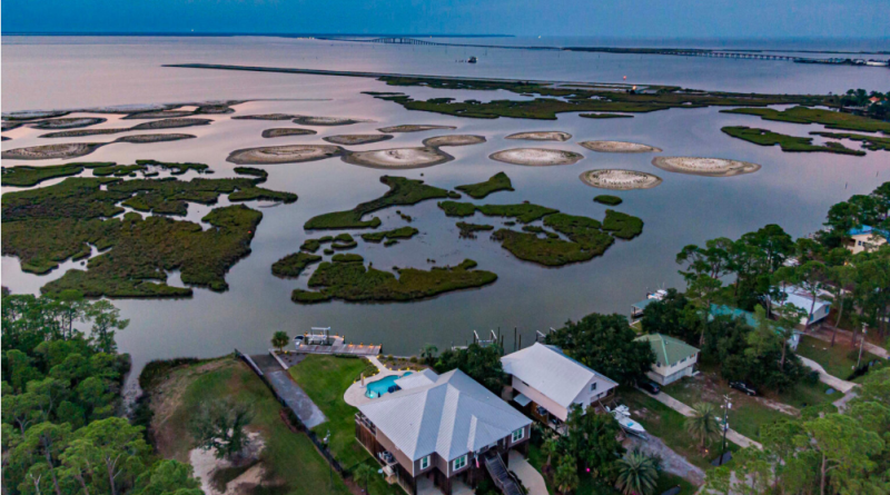
Cover photo: An aerial view of Dauphin Island’s shoreline and marsh mounds in Alabama. Credit: Lee Hedgepeth/Inside Climate News