An Atmospheric River Brought This Week’s Flooding Rains to the Southeast
Climate change makes heavy rain even heavier, beginning with warmer waters in the Gulf of Mexico that produce more evaporation into the atmosphere.
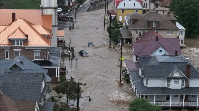
After early signs of drought from Georgia through Virginia this spring, a slow-moving storm brought flooding rain to the Southeast this week. Between 5 and 10 inches of rain fell in parts of Georgia, the Carolinas and Virginia.
The Potomac River, from West Virginia to Washington, D.C., flooded, and like many of the rivers between there and Georgia, their levels will remain high through the weekend.
The multi-day rain came from a system that formed in the Deep South, but understanding how it produced so much rain requires looking higher in the sky.
The movement of air 3-4 miles overhead, at the jet steam level, governs how storms develop and move. Usually, that air moves west to east across the country with a few smaller waves nudging north and south as it flows east. In most cases, it brings periods of rain for about a day and then exits.
But occasionally, some of that flowing air overhead breaks away from its primary jet stream path and begins to spin horizontally. The effect is similar to the formation of slow-moving eddies adrift along a riverbank, far removed from the more rapid water flowing in the middle of a riverbed.
This tends to happen more in the late spring, as the fastest winds of the jet stream retreat northward into Canada after spending much of the winter and early spring across the United States, leaving behind broad areas of spinning air to slowly drift along.
These areas of spinning air, often referred to as cut-off lows, slow down the progression of weather systems and often lead to prolonged periods of similar weather.
Atmospheric Rivers
In addition to the cut-off low, a deep pipeline of moisture was pulled northward from the eastern Gulf of Mexico into the Southeast. This atmospheric river of moisture is not a new phenomenon, but its name is, having been adopted into the meteorology canon after being first proposed in 1994.
Similar to rivers running along the ground, atmospheric rivers are narrow areas of racing water, but in this case, water vapor is being moved rather than liquid water.
These firehouses of moisture come in many sizes, but on average, they are 1,200 miles long, 300 miles wide, and 1-2 miles deep. As a result, they move far more water than any river along the ground: The strongest atmospheric rivers discharge water at more than 10 times the rate of the Mississippi River.
Atmospheric rivers often make news by bringing heavy precipitation to the West Coast during the late fall, winter and early spring, as they are the dominant way to get rain into the lower elevations and snow along the Sierra Nevada.
However, they do occasionally form in other parts of the world when the air movement through a deep layer of the atmosphere lines up in the same direction and originates over warm, tropical waters. Such was the case this week in the Southeast.
Warm Gulf Waters
The water in the Gulf of Mexico was 1 to 3 degrees Fahrenheit warmer than normal as this system came together, leading to more evaporation into the atmosphere and yielding heavier rainfall.
Not surprisingly, these atmospheric rivers will hold more moisture in the warming climate, increasing the risk from stream and river flooding, and in turn, the costs to recover from the flooding.
Precisely how much more rain can be traced to climate change requires a more formal review, but there are similarities between this event and a multi-day heavy rainfall in April that impacted the middle Mississippi Valley, where the Ohio and Tennessee rivers also converge.
An analysis of that event from scientists at World Weather Attribution indicated that there was a 9 percent increase in rainfall intensity due to the warming climate. Projecting forward on the current path of planetary warming by 2100, the chance of a similar flooding rain would double, and its intensity would increase by an additional 7 percent.
The relationship between a warmer atmosphere and its evaporation potential is not linear, as the amount of evaporation goes up exponentially in response to the temperature. This is one reason why weather systems originating in the tropics—like hurricanes—tend to produce more rain than their non-tropical counterparts.
Hurricane Season and NOAA Cuts
The Atlantic hurricane season begins on June 1. Budget cuts at the National Oceanic and Atmospheric Administration, resulting in the loss of weather data and limited staffing, will impact the quality of forecasts, although the extent remains an open question.
Hurricanes will not go unseen, but the loss of data from the research branch of NOAA will degrade the accuracy of the forecasts, giving back all of the forecast progress gained over the last quarter-century, if not longer.
An average hurricane season brings 14 named tropical storms, with seven of those growing to become hurricanes. In April, forecasters at Colorado State University said they expect this season to be more active than usual.
The warming climate continues to favor stronger hurricanes and ones that intensify more rapidly, making the forecast challenging enough.
Loss of resources will make forecasting the specific time and location of the heaviest rain more difficult, endangering more American lives and property. In Virginia, floodwaters from this week’s atmospheric river swept up and killed a 12-year-old boy.
Cover photo: The Potomac River floods downtown Westernport, Md., after extreme rain on May 13. Credit: Ricky Carioti/The Washington Post via Getty Images