Weather tracker: Storm Bora lashes Greece with torrential rain and gale-force winds
Flash flooding and widespread disruption on Greek islands, while Australians experience unusually wet start to summer
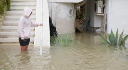
Greece was hit hard by Storm Bora last weekend, with torrential rain, gale-force winds and intense thunderstorms affecting the islands of Rhodes and Lemnos in particular.
The storm formed on Friday 29 November and rapidly intensified by Saturday, with wind speeds reaching up to 80mph (129km/h). Rhodes had 300mm of rain, which caused flash flooding and widespread disruption. Three people were killed and power outages, school closures, overturned vehicles and collapsed bridges were reported.
Authorities declared a state of emergency in places, with more heavy rain expected in Rhodes and other eastern Greek islands in the coming days.
Storm Bora was triggered by a low-pressure system over the Ionian Sea, which moved eastwards across Greece. December is typically Greek’s wettest month, and Storm Bora follows Storm Alexandros, which also formed in the Ionian and hit the region a month earlier.
Meanwhile, Australia has had an unusually wet start to its summer. Severe thunderstorms have swept across the eastern regions, bringing heavy rainfall – more than 100mm in some areas – and large hailstones. Sydney, Brisbane and Victoria were worst hit.
Flash flooding submerged parts of Brisbane after 40mm of rain fell in an hour on Sunday. Queensland had more than 200mm in less than 24 hours, while Sydney recorded 25mm in an hour.
The storms were triggered by unstable air, reinforced by an upper-level trough. This trough caused a phenomenon called cooler air aloft, which enhanced the upward motion of warm, moist air at the surface, increasing atmospheric instability and promoting thunderstorm formation.
According to the Australian Bureau of Meteorology, the country is expected to experience a warmer-than-average summer, with above-average rainfall across eastern and north-western regions in December. This is caused by warmer sea surface temperatures, which increase atmospheric humidity. Combined with atmospheric instability, this provides ideal conditions for frequent thunderstorms in the weeks ahead.
Over the past few days in South America, severe thunderstorms have affected Brazil, Uruguay, and Argentina. Triggered by a cyclone along the coast of Uruguay, the storms brought heavy rain and winds above 50mph.
The southern Brazilian state of Rio Grande do Sul was hit particularly hard, with powerful winds causing widespread power cuts that affected about 3 million people. As of Wednesday 4 December, at least 50 people have been injured and significant damage to homes and infrastructure has been reported.
Cover photo: By The Guardian


