A drowning world: Kenya’s quiet slide underwater
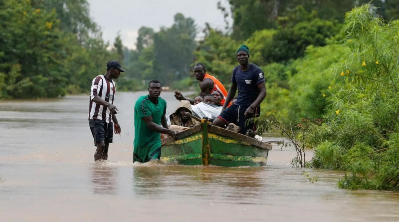
Kenya’s great lakes are flooding, in a devastating and long-ignored environmental disaster that is displacing hundreds of thousands of people
One of the first scientists to realise that something was wrong with the lakes was a geologist named Simon Onywere. He came to the topic by accident. Between 2010 and 2013 he had been studying Lake Baringo, Kenya’s fourth-largest lake by volume. The bones of residents of the area around the lake weaken uncommonly fast, and Onywere was investigating whether this may be linked to high fluoride levels in the water. Then, in early 2013, while he was meeting with residents of Marigat, a town near the lake, one old man stood up. “Prof,” he said. “We don’t care about the fluoride. What we want to know is how the water has entered our schools.”
Curious to know what the man was talking about, Onywere visited the local Salabani primary school. There, he found the lake lapping through the grounds of the school. Nonplussed, he took out his map. He looked at the location of the lake and the location of the school, and wondered how the lake had moved 2km without it becoming news.
Onywere rushed back to Nairobi, where he and his colleagues at several Kenyan universities studied recent satellite images of the lake. The images showed that the lake had, in the past year, flooded the area around it. Then Onywere searched for images of some of the lakes nearby: Lakes Bogoria, Naivasha and Nakuru. All of these had flooded. As he extended his search, he saw that Lake Victoria, Africa’s largest lake, had flooded, too. So had Lake Turkana, the largest desert lake in the world.
By September 2013, after further investigation and mapping, it was clear to Onywere and his colleagues how extreme the damage was. In Baringo, schools had been flooded and people had been displaced. Lake Nakuru, which was previously enclosed by a national park, now extended beyond it. It had increased in size by 50%.
Onywere, who has the air of a stern, experienced teacher, went to see the governor of Baringo County a few months later, but without much hope. He claims the governor showed little interest. Benjamin Cheboi, however, the then governor of Baringo County, disputes this, and says that he and Onywere never met.
Throughout the 2010s, the lakes rose slowly, and tens of thousands of people were forced to move from their homes. Then, at the start of 2020, after a particularly vicious period of rain in Kenya’s highlands, the lakes’ expansion accelerated.
Lake Turkana swept past the Barrier volcanic complex – four overlapping volcanoes that had previously separated it from the much smaller Lake Logipi, which it now swallowed whole. Lake Baringo swallowed up the lesser-known Lake 94, and proceeded inland for about eight miles, while Lake Oloiden disappeared into Lake Naivasha’s clutches. Lake Baringo, which is freshwater, and Lake Bogoria, which is saltwater, moved towards each other, threatening to become a single body of water, which would devastate the wildlife in both lakes. At one point, the lakes came within four miles of each other.
Onywere found it extraordinary how little attention was being paid to the problem. Once the pandemic took hold in March 2020, the government seemed to take even less interest. Apart from a series of publicity visits to these areas triggered by a few news reports in Kenyan media, these lakes, and the people around them, were ignored.
Kenya is a nation of lakes. If you look at a satellite image of Africa, one patch of blue stands out amid the greens of forests and the browns of deserts. Lake Victoria is situated at the meeting point of Uganda, Tanzania and Kenya. Move east, further into Kenya, and zoom in. The country is covered in blue: Lake Turkana in the north, reaching up into Ethiopia, and Lake Natron in the south, pushing down into Tanzania. Between them, running in a line down the western half of the country, a smattering of smaller lakes: Baringo, Bogoria, Naivasha, Nakuru, Magadi. All these lakes are in the Kenyan section of the Great Rift valley, an elongated lowland region formed by tectonic plates moving apart from one another, which runs 4,000 miles south from Lebanon to Mozambique.
As a child, Kenya’s lakes loomed large in my mind. I grew up in the city of Kisumu, on the shores of Lake Victoria. I remember my excitement at the discovery that Victoria was the second-largest freshwater lake in the world, and third-largest lake overall. Here was something we Kenyans excelled at, I thought. Lakes! Every few months, my family and I would spend an afternoon by the water’s edge. At Impala Park, you could picnic by the water while gazelles grazed next to you. At Hippo Point, boat rides awaited, as well as the occasional hippo sighting. We used to skim stones aross the water’s surface, and count how many times we could make them bounce.
Kenya’s lakes are vital to the country’s people, economy and wildlife. A few are salt lakes, which sustain abundant marine and bird life – among them, flamingos, endangered species of eagles and vultures, and cranes – as well as local industries. Lake Magadi provides more sodium carbonate – used in cleaning products, food production and glass manufacturing – than anywhere else in Africa. Other Kenyan lakes – Turkana, Baringo and Naivasha – are freshwater, and support the roughly 1 million people who live near them. Water from Lake Naivasha supports most of Kenya’s flower industry. Kenya is the third-largest exporter of cut flowers in the world, and 70% of these flowers go to Europe.
Over the past decade, as these lakes have risen, they have become a source of alarm rather than pride. Hundreds of thousands of people have been displaced from their homes. And this seems to be just the start of the disaster. A recent UN report about Lake Turkana declared that flooding, which was until recently considered a rare event, “is likely to become more regular” unless adaptation measures are put in place.
Last year, I spent a few weeks travelling across Kenya to see the rising lakes for myself. From Kenya’s capital, Nairobi, I first drove north-west to Nakuru, 100 miles from Nairobi, descending steep escarpments and into the Rift valley. Then I drove 60 miles north to Marigat, the nearest big town to Lake Baringo and Lake Bogoria, where Onywere had begun his research. On my first day in town, I met George Okeyo, the ranking education official in the area. Okeyo settled into his plush leather office chair and began to speak.
The rapid expansion of Lake Baringo had started in December 2019, he told me. Baringo is a desert area but for about three months, until March 2020, there had been heavy downpours. Residents of the area expected that when the rain stopped, the lake would retreat. Instead, it kept rising. In March 2020, as Covid spread, schools across the country closed. When they reopened seven months later, 11 schools in Marigat had been completely submerged by the lake.
In one school, from their desks, the students could see hippos frolicking. Okeyo told me that crocodiles had killed two children who had been playing at one of the schools before they reopened. To deter these animals, thorny poisonous mathenge trees were planted to serve as walls. But there were multiple news stories of other crocodile and hippo attacks in the area.
A few local schools had received donations from the national government and from charities, but Okeyo dismissed these as pitiful: a few tents, and some corrugated iron sheets for building classrooms. When Okeyo went to the Ministry of Education in Nairobi at the start of 2021, the records showed that each of the secondary schools around Lake Baringo had been allocated 10m shillings (£67,000), and the primary schools 4m shillings (£27,000) each. “The officer I was talking to said the money had been sent,” Okeyo said. On the ground, these schools knew nothing about the money. (Some financial assistance arrived months after I visited, more than a year after the schools were flooded.)
The next day, Okeyo and I set out to visit some of the schools that had relocated. At Ng’ambo primary school, whose student population had dropped down to 40 children from a pre-pandemic high of 500, classes were under way beneath the shade of trees and in two white Red Cross tents. Outside one tent was the staffroom: a bench where teachers sat, grading exam papers. In one outdoor class, a teacher took his pupils through some English grammar. Today’s lesson was capital letters. Around the children, goats walked in the dust.
Mr Parkolo, the headteacher, told me that what used to be the school’s classrooms were now submerged, nine miles away. Then, noticing my camera, he instructed the teachers to gather at the staff bench for photos. He told the children to put on their face masks. We were in the middle of a pandemic, after all.
A few hours later, I visited the old site of another school, Salabani secondary. Here, the lake had receded a bit, so we could explore. A group of children, who were not students at the school, led me, as well as the principal of the school and his deputy, through the floating water hyacinth that was everywhere in the compound. We walked past hippopotamus footprints and stepped on to an elevated room that used to be the classroom for form two. Before us was the lake. Pelicans, white and hungry, waded in the water. The principal, Moses Chelimo, pointed out what used to be a boys’ dormitory, now barely visible across the water. Behind it was the school farm, where two hectares of maize grown to feed the students was underwater. One of the children who had guided us into the school said that a hippo usually sleeps next to one of the classrooms. I asked him if it sleeps inside. “Haizetosha mlango,” another child said. (“It doesn’t fit past the door.”) We all laughed.
I looked to my right. There was a stretch of water, and then a series of classrooms with elevated verandas. Two fishermen were using one of the classrooms to dock off. Because they didn’t want to make too much noise and scare away the fish, they were using rafts which they propelled using plastic oars.
The boys got excited. A hippo! They pointed to it in the water, its head visible. Chelimo was unmoved. He told me that there were a lot of the hippos where the teachers’ quarters had been, swimming around the rows of houses that were now underwater. He and the deputy, Kibet Zakayo, looked out across the lake, surveying what used to be their school.
Everywhere I went, people had theories about what was happening to the lakes. One explanation is that the rise of the lakes is cyclical. “I hear that it happened in the 1940s, but I wasn’t alive to know,” a local in Ahero, near Lake Victoria, told me. When I spoke to Lawrence M Kiage, a professor of geography at Georgia State University, who studies the history of climate breakdown in east Africa, he said something similar: “If we go back in time, the Rift valley lakes have had higher levels. What we are seeing now is not something new.” Sean Avery, a hydrologist who has lived in Kenya since 1979, has pointed out that the current level of Lake Turkana is no higher than it was in the 1970s or in the 1900s.
Other popular explanations focus on the lakes’ location: the rising Kenyan lakes are almost all situated along the eastern branch of the Great Rift valley. (The western branch stretches from the north of Uganda to the south-east of Tanzania, and its lakes are rising, too, albeit more slowly, displacing families in the Democratic Republic of Congo, Burundi and Uganda.) Many observers find this too striking to be a coincidence: they feel that the rising lakes must be connected to tectonic activity. The Great Rift valley is splitting apart at a rate of roughly 2mm a year, and will at some point in the next tens of millions of years eventually separate east Africa from the rest of the continent. A common theory I heard was that, as the Rift valley separates, fresh groundwater has been brought to these lakes from a previously unknown underground aquifer.
When I asked Onywere whether the tectonic movement of the Rift valley could be the cause of the current expansion of the lakes, he dismissed the suggestion instantly. For him, the fact that Lake Victoria was also rising, despite not being on either branch of the Rift valley, disproved any tectonic theories. Instead, Onywere told me, what was happening was a result of the climate crisis. There had been more rain in the Kenyan and Ethiopian highlands, and the volume of the rivers feeding these lakes had increased. Since 2010, Kenya has received more rainfall than usual – the yearly average has been significantly up on 2010’s 650mm almost every year since. In 2019, Kenya received the third most rainfall it had ever recorded.
While accepting that tectonic theories do not explain Lake Victoria’s rise, Kiage isn’t completely sure that anthropogenic climate breakdown is the cause. “I’m not trying to downplay the role of humans,” he told me. “Humans are clearly doing something, but it can’t explain the sudden rise.” What was needed, said Kiage, was a molecular investigation of the water, to determine where it was coming from.
For years after he first stumbled upon the problem, Onywere had also been pushing the national government to study the rising lakes and to determine how best to help the people who had been affected. In October 2020, he got his wish. The government announced the formation of a multi-agency team of geologists and hydrologists that would investigate the rise of the lakes. Onywere was appointed head of the team to Lake Turkana.
On the hot June morning I visited, as I edged over the crest of a rocky hill, the greenish-blue hues of the water glinted next to the road, the desert sunlight reacting with the water’s alkali matter to give the lake its nickname, The Jade Sea. In a village on its shores, the El Molo people who live there mourned the rising of the lake. The village elders told me how, with the movement of the water, they had been forced to move their village, Luyeni, carefully uprooting their thatch houses and relocating them further from the lapping water. As we spoke, white gulls floated lazily over the water, wafted along by a zephyr.
The elders had noticed the lake increasing in size, and through their fishing expeditions, they knew that it was becoming deeper, too. They told me about a road that had last been used 10 years ago, before it went underwater, and predicted that the road I had taken to come to Luyeni would also soon be underwater. They knew, too, that this is not solely a Turkana phenomenon; they had heard that the same thing was happening in other Rift valley lakes, as far away as Kisumu. The elders had their own theories about what was happening to their lake, Mpaso, in the local El Molo language. “Maybe there’s a broken spring in the ground, and the rocks have cracked, so it’s throwing water up,” one of them said. Maybe River Omo in Ethiopia is the one with the crack, another elder offered.
In August 2021, the Ministry of Environment told the media that once the multiagency report on the lakes was published, the Kenyan government would be appealing to the international community for assistance. In the short-term, 3bn shillings (£20.1m) was needed. Longer term, an extra 5bn was needed.
But a number of people on the team that prepared the report shared with me their scepticism about the government’s interest in helping the victims of the rising lakes. Instead, they suggested, what really motivated Kenya’s notoriously corrupt political class was the prospect of international donations. After all, these lakes had not risen in secret. They had been rising steadily for 10 years. Only when the UN Environment Program published its own report about Lake Turkana in July 2021, and the prospect of foreign aid became more likely, did Kenya’s politicians really become interested. A number of people I spoke to were angry at the apparent insinuation that help was meant to come from the international community, rather than from the Kenyan government itself. The government, Okeyo had told me in his office in Marigat, did not care about the plight of minority communities such as those who live around Lake Baringo.
In October 2021, the government finally released the report. While allowing for the possibility that tectonic activity was partly responsible, it stated that greater levels of rainfall, caused by the climate crisis, was the main cause. Other forms of human interference with the environment – such as deforestation – had also led to landslides and increased water runoff, which had in turn contributed to the rising water levels. The report noted that nearly 400,000 Kenyans had been displaced, and that they required “urgent humanitarian assistance”.
The impact was particularly severe around Lakes Victoria, Naivasha and Baringo, which support densely populated areas. On the edge of Lake Naivasha, about 50 miles west of Nairobi, I visited a settlement named Kihoto, where 4,000 families had been displaced. There I waded through the water with a landlord named Gideon, who had stayed in the area after the flooding in order to guard his houses, which were now empty. On the news, he had seen government representatives claim that relief food had been given to the residents of Kihoto, but he said that hadn’t received any. This was a common refrain as I traversed the country. In Loruk, a town next to Lake Baringo, I had met a man named Wesley Jeptumo, who complained that apart from a Red Cross team that had arrived to take photos of the flooding, no one had come to help. Near Lake Victoria, the motorbike taxi driver had told me that residents had seen my car and thought I was Raila, a popular Kenyan politician – someone here to help them at last. Their disappointment on discovering that I was a freelance journalist must have been deep.
The morning after my initial meeting with Okeyo in Marigat, I’d taken a boat ride at Kampi Ya Samaki, a fishing centre on the shores of Lake Baringo. The sun, just risen, filtered its rays through thin grey clouds. Everywhere, there were birds. From the top of one tree, an eagle dived into the water and emerged with a fish in its beak. On the tips of other trees, long-tailed cormorants, Madagascan bee-eaters and kingfishers perched, looking for food. The boat operator, Evans Limo, pointed out buildings that were in the water. Here, some houses. There, the local health centre. Some churches. Ostriches, which had been kept as pets by a hotel that was now half-submerged, roamed around the dry parts of the hotel’s grounds.
Most disturbing were the tall trees that stood inside the lake, brown and leafless. Almost everywhere I went, it was the dead trees that haunted me. Inside Dunga Hill Camp, a popular picnic site next to Lake Victoria, pools of water surrounded jacaranda trees that were planted in the colonial era. When alive and in bloom, these trees are crowded with heavy cones of purple blossom, each flower a violet bell. Now, though, they were drab and brown. Seagulls and herons took off from their dying branches.
About 110 miles east of Lake Victoria, in Lake Nakuru national park, I saw a forest that had been swallowed by the lake. Its once-green acacia trees were being slowly suffocated by the water, which has pushed beyond the bounds of the park and into Nakuru city. A decade ago, in an earlier visit, I had climbed to the top of the Menengai Crater that overlooks the city, and peered down at Lake Nakuru, its blue edged with pink – flamingos – as if by a child’s careful crayon. Then, all around, the green of a lush forest that hid lions, buffalo, leopards and other animals. But by the time of my most recent visit, the lake had pushed its way through the forest. The animals had moved to still-dry parts of the forest, but if the water continued to move, their habitats were doomed.
I looked down at the drowned giant acacias and Babu, a ranger who accompanied me, pointed out to me the houses of the Kenya Wildlife Service staff. I couldn’t see anything.
“Where?” I asked him. He pointed again. They were completely submerged.
Author; Carey Baraka
Photograph: Thomas Mukoya


