Western Canada Wildfires Are Generating their Own Weather, Experts Warn
This story includes details about the impacts of climate change that may be difficult for some readers. If you are feeling overwhelmed by this crisis situation here is a list of resources on how to cope with fears and feelings about the scope and pace of the climate crisis.
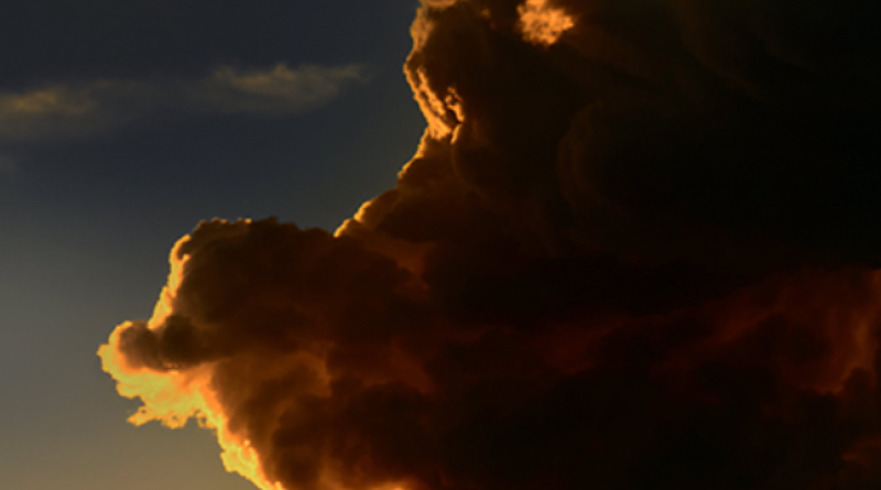
A combination of intense heat and drought conditions has been causing wildfires in Western Canada to generate their own weather systems, experts say.
Michael Fromm, a meteorologist with the United States Naval Research Laboratory, said the phenomenon is known as a pyrocumulonimbus firestorm and has been tracked this year in British Columbia, Saskatchewan Alberta, Manitoba, and Ontario, The Canadian Press reports.
Scientists have been tracking the storms since May. The first one in Canada this season was seen in Manitoba, Fromm said in an interview last week. The village of Lytton, British Columbia saw firestorms on two successive days in late June.
“It was probably the single largest pyrocumulonimbus storm of the year so far,” he said. “In fact, we’re still tracking the smoke plume from that storm as it’s travelling around the world, and it’s about to kind of come full circle back over the USA and Canada.”
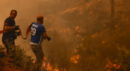
An abundance of fuel, heat, and wind create perfect conditions for the firestorms. Lytton hit a Canadian temperature record of 49.6°C the day before a wildfire erupted there, burning much of the community to the ground.
“When you get all those three things together, you get the perfect triple that we call fire weather,” Fromm said. “So, hot, dry, and windy.”
University of British Columbia climate scientist Simon Donner said the storms also generate lightning that cause more fires.
“The fire creates the storm, and then the storm creates lightning, which can cause more fires,” he explained. “That runaway feedback is the dangerous part.”
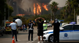
Emergency Management BC said more than 250 active wildfires were burning in B.C. as of last Monday afternoon, including 40 fires of note. Since the fire season began April 1, 4,142 square kilometres of land had been charred from 1,216 wildfires. There were 58 evacuation orders in effect, along with 83 evacuation alerts warning residents to be ready to leave their homes on short notice.
B.C. was to get more help Tuesday battling the fires last week, with 34 Australian firefighting personnel joining 113 from Quebec and 101 from Mexico. The Australian contingent included a nine-person incident management team and technical specialists.
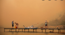
By the end of the week, poor air quality was reaching dangerous levels in cities across B.C., CBC reported, with thick wildfire smoke blanketing communities in the Kootenays and Okanagan. On Sunday, the national broadcaster said heavy smoke from 245 blazes was hampering firefighting efforts, and air quality advisories had been issued in Metro Vancouver and the Fraser Valley. On Monday, CBC said rain was bringing some relief for fire crews, and a change in weather was expected to clear the air in some of the hardest-hit parts of the province by mid-week.
Fromm said a pyrocumulonimbus storm usually begins with a smouldering fire, which feeds on the surrounding air before turning active and creating a thermal bubble. That creates a convection column that generates more energy and turns the fire hotter and larger.
“It’s just like if you have a stove and you have a small burner—you’re not going to get as much of a fast boil in your pot as if you had a really hot, intense burner,” he explained. “The big, large fire just makes it that much easier for the air to be completely upset. And then if you do form a cloud, that generates even more buoyancy that feeds back down to the fire.”
As the cloud goes “bubbling” into the air, it can create lightning, he added.
The storms last anywhere between two and five hours, occur in the late afternoon, and end when the air turns cooler or the flames run into a fire break, he said.
“When you look at it from space as we do, you can actually see several bubbles of cloud form and flatten out up in the upper atmosphere,” he said.
“Then they blow off, and then you see another bubble coming up, like several chimney bursts in the life of that individual pyrocumulonimbus. On the ground, what that means is that fire is pulsating in a way that during those two to five hours is a very dramatic and dangerous event.”
This report by The Canadian Press was first published July 26, 2021.
3 August 2021
The Energy Mix