Persistent Cloudless Skies Helped Fuel Exceptional Greenland Ice Melt.
Warm temperatures, clear weather and little snow all played a role in last summer’s major melt event on the ice sheet.
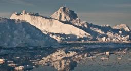
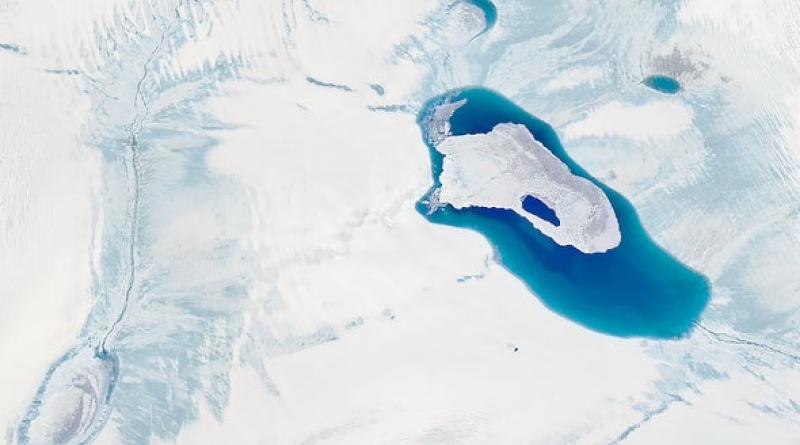
The Greenland ice sheet saw some of its highest melt rates on record last summer. Now, scientists say they know why it happened.
It’s not only that temperatures were warm in the Arctic. An unusual set of atmospheric conditions, which altered the movement of air and the formation of clouds over Greenland, was a primary driver of the melting ice.
These conditions may be linked to climate change in the Arctic, the researchers note. That raises the question of whether these kinds of extreme melting events might happen more frequently in the years ahead.
“The real question is how much, how many of these conditions, we can expect in the future,” said Marco Tedesco, a Columbia University climate scientist and ice expert, in an interview with E&E News.
Tedesco and colleague Xavier Fettweis of the University of Liege published their findings yesterday in The Cryosphere, a journal dedicated to the study of Earth’s frozen places.
Using satellite data, combined with a regional climate model, they found that last summer’s ice loss was linked to abnormally persistent high-pressure conditions over Greenland.
High-pressure systems are swirling, clockwise-moving patterns of airflow, where the atmospheric pressure tends to be higher than the surrounding atmosphere.
These high-pressure conditions affected the weather over Greenland in two important ways.
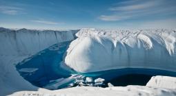
First, they led to clear skies with no clouds in the region right at the center of the system, over southern Greenland—this is a common side effect of high-pressure systems. With no clouds, very little summer snowfall occurred in this region of the ice sheet.
That was a bad starting place to begin with—shiny, white snow helps reflect sunlight away from the earth and cool the ice. Less snow on the ground allows more solar radiation to penetrate through to the surface. And because these cloudless conditions persisted for longer than normal, there was plenty of sunlight shining down on the bare surface of the ice.
At the same time, the swirling edges of the high-pressure system were sweeping up warm, moist air from the milder regions south of Greenland. The clockwise motion of the system catapulted these air pockets up the western flank of the ice sheet into northern Greenland, where they caused thick, warm clouds to form.
These kinds of clouds are excellent at trapping heat beneath them. Even with snow on the ground, they’re able to promote above-average melting in the ice sheet below.
Ultimately, both side effects—clear skies and little snow in southern Greenland, and warm clouds in northern Greenland—helped to drive high rates of melting on the ice sheet last summer.
“You have these two different phenomena related to the same atmospheric process, which are both promoting melting for very different reasons—in which of course clouds, they play the crucial role,” Tedesco said.
THE ROLE OF ARCTIC WARMING
The rate of melting on the Greenland ice sheet last summer came in second only to the melt rate in 2012, a record-breaking year. But the total amount of mass lost from the ice sheet was actually the highest on record. That’s because snowfall, which helps to make up for some of the losses from melting ice, was unusually low last year.
The 2019 melting event was even more surprising than the 2012 event in some ways, according to Tedesco.
Atmospheric conditions over the last few years should be favoring less ice melt, not more, he said. That’s thanks to a natural climate cycle that helps regulate weather patterns over Greenland and other parts of the Arctic.
The unusually persistent high-pressure conditions last summer were unexpected, compared with the kinds of weather patterns that scientists might have predicted otherwise.
When these kinds of unusual conditions occur, they can be “so powerful that they can literally eliminate any countereffect that this snowfall or anything else could have provided and actually put Greenland again on a strong mass loss track,” Tedesco said.
Persistent weather conditions in the North Atlantic are sometimes a side effect of shifts in the movement of the jet stream, a fast-flowing current of air looping the Northern Hemisphere. If the jet stream becomes less stable or “wavier” as it flows around the Earth, it can cause certain weather patterns to get stuck in place for a while.
Some experts believe that rapid warming in the Arctic is causing the jet stream to become wavier over time. It’s a high-profile debate among climate scientists, and the exact mechanisms that might cause this to happen are still unclear.
Researchers generally suggest that above-average warming rates in the Arctic are changing the temperature gradient between the high latitudes and the lower latitudes, closer to the equator. This, in turn, affects the movement of air around the Earth.
Some experts also have suggested that declines in sea ice, which can amplify the Arctic’s warming, may have an impact on the behavior of the jet stream. But not all studies agree on the matter.
If the idea is on track, though, it could mean that last summer’s conditions may occur more frequently in the future. And last summer’s melting event should serve as a warning that even a single summer can have a notable impact on the ice sheet.
“To me, this is extremely fascinating as a scientist—but it also screams for the power of these short-term events on the long-term implications” for Greenland, Tedesco said.
16 April 2020
SCIENTIFIC AMERICAN