How Is Apartheid’s Legacy Making Climate Change Impacts Worse in South Africa?

Decades after the oppressive regime ended, its impacts are still being seen in South Africa.
Climate change has already decided the theme that will define the year 2022 for Southern Africa: extreme weather and natural disasters.
Having sparked widespread drought in West and Central Africa, and sent locusts to ravage essential crops in East Africa; the beast that is the climate crisis subsequently set its sights on washing away the continent’s Southern region at the beginning of the year. South Africa is its latest victim.
Right off the back of catastrophic extreme weather in neighbouring countries Mozambique, Madagascar, and Malawi in the first three months of the year — which you can read more about here — South Africa was hit with disastrous flooding that is continuing to impact thousands of lives.
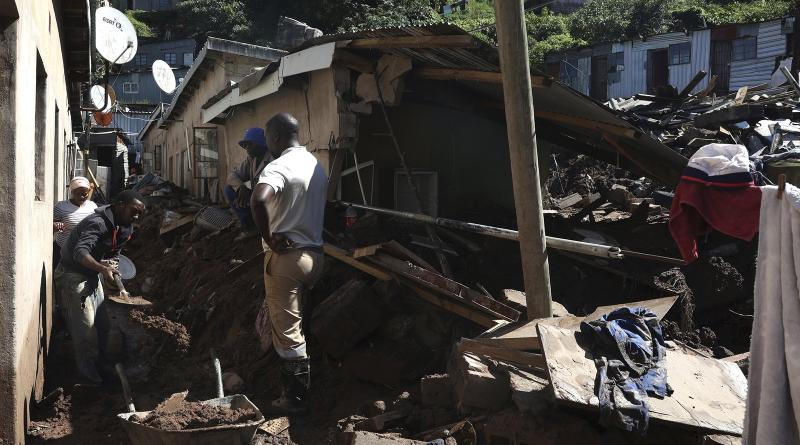
The country’s KwaZulu-Natal province experienced heavy downpours from April 8, 2022; the rains led to destructive flooding and landslides that consumed thousands of homes, businesses, and infrastructure, and killed an estimated 448 people. The damage that climate change has caused is enough of a tragedy to consider, but what if we told you that the apartheid regime — despite coming to an end back in 1994 — had its hand in making matters worse?
That’s right. The same oppressive regime to which the country owes its intense inequality and poverty rates; the same regime that is still casting a shadow over the country’s governance; the same regime that the country has been determined to run far away from — is also exacerbating the impacts of the climate crisis on South Africa and its people.
But, we hear you ask, how can apartheid, having ended several decades ago with the declaration of democracy, be connected to the impact of climate change as it’s happening today? It all has to do with apartheid-era spatial planning.
Apartheid spatial planning has always been a problematic structure in need of dismantling, it played a crucial role in separating the country’s people, and is in fact, continuing to succeed at doing just that. Now, it has become an environmental issue, and the KwaZulu-Natal flooding has put it in the spotlight as an important issue in need of urgent solutions.
What Actually Is Apartheid Spatial Planning?
In one sentence? It is the physical division of citizens implemented by the apartheid regime to systematically carry out racial segregation and the oppression of Black people and people of colour.
But the system is so much more than can be summarised in just a sentence.
South Africa is the most unequal country in the world, with huge gaps between the poor majority and a small wealthy minority. South Africa’s inequality is why former president Thabo Mbeki famously described the country as two nations, adding: “One of these nations is white, relatively prosperous, regardless of gender or geographic dispersal. It has ready access to a developed economic, physical, educational, communication, and other infrastructure…”
“The second and larger nation of South Africa,” he continued, “is Black and poor, with the worst affected being women in the rural areas, the Black rural population in general, and the disabled. This nation lives under conditions of a grossly underdeveloped economic, physical, educational, communication, and other infrastructure.”
The country’s deep inequalities also manifest in the manner in which the country’s towns and cities were built and who lives where.
Under the apartheid regime and through the use of legislation such as the 1913 Land Act and 1950 Group Areas Act, the country was designated into white, Black, Coloured, and Indian areas — with Black and Coloured areas often being the furtherst away from economic activities and usually on low lying, non-arable, and densely populated areas.
The 1913 Land Act for instance reserved just 13% of all the country’s land for Black people, and both the Group Areas Act and Land Act were imposed through forced removals which dispossessed many people from their land, homes, and families — so that white urban areas could be built.
As Statistics SA noted in a 2016 report: “The legacy of apartheid still has a hold on the social structure of South African urban space… The high density townships — dominated by Black African, Coloured, or Indian/Asian residents — are disconnected from the CBD [central business district].”
In addition to peri-urban areas (areas immediately adjacent to a city or urban area), people were also forcibly removed to rural “homelands”, which also faced challenges around development and infrastructure.
What Does Apartheid Spatial Planning Have to Do With Climate Change?
Many of the areas that were demarcated for Black people are not only far away from economic opportunities, but they are often built on areas prone to flooding — such as the densely populated Alexandra township in northern Johannesburg, which has homes built on the floodline of the Jukskei River that often floods the area. Similarly in Cape Town in the Western Cape, townships are also on low-lying flatlands that are prone to fires and flooding and often difficult to access for emergency services.
In the recent devastating floods in the KwaZulu-Natal province, some of the worst affected areas were poorer townships and those areas that were built on flood lines. In 2019, following heavy rains that also led to flooding, the eThekwini municipality (a district in KwaZulu-Natal) released its climate action plan, which noted that heavy and disruptive rains would become more frequent for their area.
The climate action plan also noted that poorer areas would be the most vulnerable to flooding and drought, stating: “EThekwini Municipality recognises that people living in informal settlements are the most vulnerable communities in the city. Many informal settlements are situated in environmentally sensitive areas, including floodplains, low-lying areas, or on land with steep slopes or unstable soils.”
The plan highlighted at the time that around 25% of the city's population were living in over 550 known informal settlements — and 164 of these, or about 1 in 3, are located or partially located on floodplains. The report also noted that homes in these poorer and vulnerable areas were often made with materials that would not withstand extreme weather events.
Following the floods in KwaZulu-Natal this month, Dr. Nkosazana Dlamini-Zuma, South Africa’s Cooperative Governance and Traditional Affairs Minister, said in a press briefing that poor spatial planning had played a crucial role in the devastation in the province.
What Needs to Be Done?
Little has been done to address apartheid spatial planning in the years since apartheid ended, and South African cities are still largely segregated along racial lines — meaning the country’s poor continue to live in isolated, rural, poorly built, and under-resourced areas. In addition to this, municipalities are not spending enough on infrastructure — including spending on infrastructure intended to make South African communities more resilient to climate change.
South Africa’s Auditor General has regularly raised the alarm about the minimal amount of money spent on infrastructure, and the challenges relating to infrastructure projects not being completed and/or maintained. An investment in the building and maintenance of public infrastructure is therefore a crucial part of preparing and safeguarding poor communities as the effect of climate change increases.
Furthermore, South Africa’s own National Development Plan (NDP) acknowledges the importance of planning for climate change, especially for poorer communities. The NDP says, “developmental challenges must be addressed in a manner that ensures environmental sustainability and builds resilience to the effects of climate change, particularly in poorer communities.”
South Africa is often criticised for being a country with great policies and plans but that are frustrated or made ineffective by a lack of political will and follow through. This inertia must be addressed to address high levels of poverty and inequality in the country, including preparing for extreme weather which will become more frequent.
Another issue that needs immediate attention is the failure on the part of wealthy countries to deliver on their promise of $100 billion a year every year from 2020-2025 to help low-income countries (which contributed the least to cause the climate crisis) adapt to climate change — a pledge that countries have now said won't be met until 2023. This funding could go a long way in countries like South Africa that are currently experiencing some of the worst impacts of climate change so far.
How Does It Impact the Mission to End Extreme Poverty and Its Systemic Causes?
Natural disasters alone are a major cause of destruction and a significant obstacle in the mission to end extreme poverty, leaving nations to spend considerable resources on recovery and rebuilding. Add the impact of spatial planning into the mix — knowing that without it, the effects of natural disasters in South Africa would not be as immense — and poverty is undoubtedly exacerbated.
Unsurprisingly the climate crisis is directly related to Global Goal 13, which calls for immediate climate action. The lack of action from current leaders to rectify the planning of the past — that is unnecessarily extending the way climate change is affecting South Africa — is fueling the climate crisis fire in the country.
When it comes to its citizens, extreme weather also means school children have lost their access to education (impacting Global Goal 4), with the local Department of Basic Education estimating that the floods affected an estimated 630 schools, with just over 100 being entirely inaccessible. The flooding also has the potential to impact children’s access to basic nutrition (Global Goal 2 for zero hunger), as around 9 million children in the country depend on school meals for nourishment, and an estimated 1.7 million of these are from KwaZulu-Natal.
As infrastructure was destroyed or washed away with the storms (including around 4,000 homes), so were essential health care facilities and clinics, without which, life-saving health services will become unavailable to those who need them most. According to the officials in the province, an estimated 58 hospitals have been affected by the intense storms, impacting the UN’s Global Goal 3 for access to health care.
The fact that spatial planning itself still exists and has not been effectively dealt with, has an impact on Global Goals 9 for industry, innovation, and infrastructure, where there is a lack as affected regions tend to be underdeveloped or neglected; as well as Goal 11 for sustainable cities and communities. Apartheid spatial planning is yet another way that inequality is continuing to define South Africa.
Finally, in terms of infrastructure and rebuilding, local officials estimate that around R17 billion (just over US$1 billion) will be needed to recover from the impacts of the storm. There is no word on whether this amount includes building smarter and more inclusively, away from previous structures, but government officials have confirmed with Global Citizen that there is now planning and discussion around rectifying spatial planning in the country’s most vulnerable areas.
What Action Can We All Take to Help?
The climate crisis will continue to hit Africa the hardest, and if immediate action is not taken, devastating floods and extreme weather patterns will only continue.
Take action with us by learning more about how the climate crisis is affecting the African continent as a whole. Sign up to be a Global Citizen, either on our website or by downloading the Global Citizen app, and take this quiz action to understand more about the situation.
You can also take action to help make sure that wealthy countries honour their commitments to helping low-income nations adapt to the climate crisis by tweeting relevant world leaders here.
To help with immediate relief for those impacted by the KwaZulu-Natal flooding, you can also support GlobalGiving's South Africa Flood Relief Fund — which helps vetted partner organisations to provide food, water, and emergency medical supplies to people and displaced families — by donating here. You can also learn about other meaningful ways to help here.
cover photo:
People clear mud from damaged houses following floods, at Clermont in Durban, South Africa, April 14, 2022. | AP Photo


