That sinking feeling: Australia’s Limestone Coast is drying up
Groundwater levels are plunging in a rich agricultural region dubbed the Green Triangle. It’s a slowly unfolding disaster
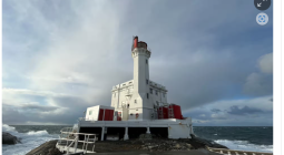
Graham Kilsby, a fourth-generation farmer, is surveying the Kilsby sinkhole, a popular freshwater diving site on his property south of Mount Gambier.
The gin-clear waters provide visibility of up to 65 metres. But, as he inspects the sinkhole when Guardian Australia visits, alarm bells ring. Water levels dropped 1.5 metres between January and March 2025.
It’s a long-term decline, made worse by South Australia experiencing one of the driest years on record since 1900. And it’s not confined to Kilsby’s property: the entire vast groundwater network in the limestone crust that straddles the border between South Australia and Victoria – an area of such agricultural richness that it has been dubbed the Green Triangle – is in decline, thanks to decades of over-extraction and declining rainfalls. Monitoring of 181 groundwater wells by SA authorities shows a consistent decline since 1993, with some, particularly in areas of intensive irrigation and forestry developments, dropping by several metres.
We’re here to explore the sinkhole alongside a group of experienced freedivers. And, as Kilsby says, to “see it before it’s gone”.
It’s reckoned to be one of the best dive sites in the world to descend on a single breath. By day, divers move through brilliant shafts of light piercing the cave. By night, glow sticks are their only markers, 25 metres below.
It’s a remarkable experience – one Kilsby wants protected.
“We need an independent review of currently available [water use] data, as well as a moratorium on any new bores,” he says.
“It’s not something we can look at in three years and everything will be OK. If we don’t change what we’re doing, I think we’ve destroyed it and it won’t be coming back.”
Little Blue Lake
One month before diving at Kilsby sinkhole, we’re at Little Blue Lake, a large freshwater sinkhole a 15-minute drive south of Mount Gambier. It’s a 35C day in January and the lake is buzzing with swimmers seeking relief in waters that remain 14C year-round.
The once crystal-clear lake now often appears steel-grey or green, its water quality compromised by persistent algae blooms caused by excess nutrients in the water from agricultural runoff and wastewater. Waste from the lake’s thousands of visitors also built up, with some guests reporting seeing human faeces littering its perimeter before a portable toilet was installed in January.
Teenagers gather at the rim, waiting to take the “leap of faith” – a 12-metre drop that’s a local rite of passage. The crack and thud of awkward landings echoes off the deep walls. The leap has grown riskier as water levels hit historic lows. “See that ledge the kids are sitting on? That’s new,” one local remarks.
Closer to the coast are a series of karst rising springs, wetlands formed by groundwater rising to the surface under pressure, creating a permanently saturated peat soil. That water then feeds the region’s most well-known sinkholes, the Piccaninnie and Ewens ponds.
But both are now closed due to low flows and algae outbreaks. Piccaninnie Ponds, a Ramsar-listed wetland of international importance, has been closed since 2022 and snorkelling and diving at Ewens Ponds was suspended in February.
The ponds rely on constant, fast-moving groundwater flow. Claire Harding, a conservation ecologist at the SA National Parks and Wildlife Service, says water flows at Piccaninnie and Ewens have reduced by 62% and 25% respectively since the 1970s.
“Anything that affects groundwater is going to also impact Piccaninnie and Ewens,” Harding says.
In 2020 both Picanninie and Ewens were listed as nationally endangered ecosystems.
In January the SA lieutenant governor, Dr Richard Harris, an anaesthetist and experienced cave diver who received international acclaim for the crucial role he played in the rescue of schoolchildren trapped in a cave in Thailand, conducted a dive at Piccaninnie with the National Parks and Wildlife Service to help guide any potential reopening.
“What I saw earlier this year when I did that dive was shocking,” Harris says. “It’s a real disaster unfolding.”
The Green Triangle
The lush pastures and usually high rainfall of the Green Triangle make it a highly productive agricultural region. The Limestone Coast produces a third of SA’s agricultural output, despite being just 2% of its landmass. Across the border in Victoria there are 1,000 dairy farms in the south-west alone, producing 2bn litres of milk – 23% of all national production – each year.
The South Australian Dairyfarmers Association chief executive, Andrew Curtis, says any cuts to water allocations could impact dairy businesses.
The less-successful dairy farms are slowly being bought up by forestry interests, increasing an already vast expanse of blue gum and radiata pine plantations. The fast-growing trees drink up the groundwater and absorb runoff, causing aquifer levels to plummet. A 2009 report by the SA Department of Water, Land and Biodiversity Conservation found that hardwood and softwood forests cut water recharge to the aquifer by 78% and 83% respectively, when compared with dryland agriculture.
Since the mid-1990s, groundwater levels in heavily irrigated areas have also declined. Conservation advice provided in 2020 to the federal government on the karst springs’ endangered listing under the Environment Protection and Biodiversity Conservation Act linked that decline in part to the use of centre-pivot irrigation, which consumes much more water than other forms of irrigation.
There are now 3,000 water licences allowing irrigators and landowners to draw groundwater from the region for non-domestic use.
Bool and Hacks lagoons
About 100km north of Mount Gambier are the Bool and Hacks lagoons. The seasonal, interconnected wetlands earned Ramsar status in 1985 and were once famous for flocks of migratory birds.
“Dad used to say Bool in flood was better than Kakadu,” says Marion Patterson, a fourth-generation Bool local.
Patterson is speaking from the bird room, a collection of 600 taxidermised birds and 350 fauna specimens put together by her father, the duck hunter turned conservationist and master taxidermist, Jack Bourne. It’s open to the public via appointment.
Many of the birds here were once regular visitors to the lagoon. There’s a brolga that hit a power line and started a fire, several birds of prey, smaller wrens and a little grebe.
Bool and Hacks are fed by Mosquito Creek, a once-permanent source of water which is now dry. Dr Matt Gribbs, a CSIRO hydrologist, says the creek began to dry up at the end of the 1990s and now “there is only flow for 15-20% of the time”.
The collapse of the lagoons is a slow-moving crisis, and the regulatory response has been even slower. A plan to reduce water allocations in high-risk areas, recommended in 2013, was put on hold in 2018 when Steven Marshall’s Liberal state government blocked any changes, instead calling for an independent review of the science underpinning the proposed cuts.
That review was published in 2019 and described ongoing “catastrophic consequences” to Bool and Hacks lagoons, and to the karst springs farther south, due to intensive land use and historical drainage in both areas. That warning was consistent with the 2013 plan.
The Landscape Board – a body set up in 2019 to manage SA’s landscapes – told Guardian Australia the warnings have been around for “decades”.
In 2024 an extensive review of regulations noted: “The overall scheme of management has not changed significantly since 2004.” The water allocation plan is not due to be updated until December 2027. A SA government spokesperson said decisions would be made on the best available science.
Despite the acknowledged decline, there has been no official report to Ramsar on the Bool and Hacks lagoons since 1998, and no report on Piccaninnie Ponds since 2012. The Ramsar convention requires governments to make a report if the ecological character of a site changes or is likely to change due to human activities.
A spokesperson for the SA government said the department was “documenting information about the current status of Bool and Hacks lagoons and Piccaninnie Ponds, in line with the requirements of the EPBC Act and the Ramsar Convention”.
Ewens Ponds
Ewens Ponds was open for a few fleeting weeks early in the new year, before being closed in February. In that brief window, a Boandik (Bunganditj) man, Uncle Ken Jones, who runs a tourism business on the Limestone Coast, steps into the cool water, taking a deep breath before diving into blue. “It’s just magic,” he says, resurfacing with a grin.
His joy is precarious, resting on the health of a dying ecosystem.
“If we don’t do something about it in the next few years, it rests upon our soul,” he says. “We really should have spoken up and influenced some people to care for it a bit better rather than just take, take, take.”
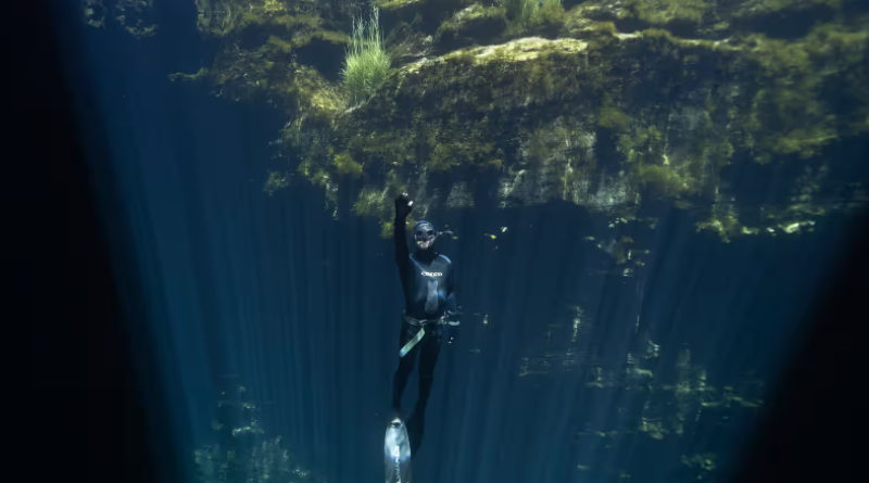
Cover photo: A free diver goes deep at Kilsby sinkhole, part of a vast groundwater network in the limestone crust that straddles the border between South Australia and Victoria. Photographs: Brook Mitchell/The Guardian