Extreme Heat, Wildfires and Record-Setting Storms Suggest the Future Climate Crisis Is Already Here.
From the historic heat wave and wildfires in the West, to the massive derecho that tore through the middle of the nation, to the record-breaking pace of this year's hurricane season, the unprecedented and concurrent extreme conditions resemble the chaotic climate future scientists have been warning us about for decades — only it's happening right now.
While climate catastrophes are typically spaced out in time and geographic location, right now the U.S. is dealing with multiple disasters. The Midwest is cleaning up from a devastating derecho that caused nearly $4 billion in damage to homes and crops, as nearly a quarter-million people in the West are underevacuation orders or warnings from fires that have burned over 1 million acres, and at the same time residents along the Gulf Coast are bracing for back-to-back landfalls of a tropical storm and hurricane.
"This current stretch of natural catastrophe events in the United States are essentially a snapshot of what scientists and emergency managers have long feared," says meteorologist Steven Bowen, the head of Catastrophe Insight at AON, an international risk mitigation firm.
Michael Mann, a distinguished professor of Atmospheric Science at Pennsylvania State University, happened to be in Australia on sabbatical last year and witnessed the devastating wildfires there — a similar scene to what is playing out in California right now. For years Mann has sounded the alarms about the acceleration of human-caused climate change, but even he is somewhat surprised at the pace.
"In many respects, the impacts are playing out faster and with greater severity than we predicted," he said.
To be sure, these events are not all related to each other, but the one thing they do have in common is that climate change makes each one more likely. The simple explanation is that there's more energy in the system and that energy is expended in the form of more extreme heat, fire, wind and rain.
It may be tempting to look at these extremes as a "new normal," but Dr. Kevin Trenberth, a distinguished senior scientist at the National Center for Atmospheric Research, says while it may be new, it won't be normal.
"For some time we have talked about a 'new normal' but the issue is that it keeps changing. It does not stop at a new state. That change is what is so disruptive," he said.
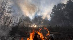
California Wildfires
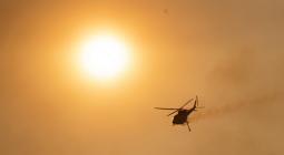
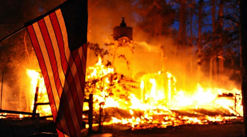
The fires unfolding in California right now have no parallel in modern times. With more than 1 million acres burned in just one week, the season is already historic with more acres burned in this past week than is typical of an entire year. Two of the state's top three largest fires on record are burning at the same time — the LNU and SCU complex fires — with the likelihood that one of these will take over the top spot soon.
As of Monday morning, CalFire reports over 7,000 fires have burned more than 1.4 million acres this season, overwhelming resources to the point where many of the smaller fires are being allowed to burn. CalFire stated that to fight these fires to the maximum of their ability, the agency would need nearly 10 timesmore firefighting resources than are available.
As is the case in any natural disaster, the cause can be traced to multiple coinciding events. In this case, the spark for most of these fires was a siege of lightning strikes as a result of moisture drawn into California from two decaying tropical systems in the eastern Pacific, which ignited dry brush.
Daniel Swain is a well-known climate scientist who specializes in studying the link between climate change and weather in the West at the University of California, Los Angeles. In a blog post he described how even someone like him, well-versed in climate disaster, is shocked by the current situation: "I'm essentially at a loss for words to describe the scope of the lightning-sparked fire outbreak that has rapidly evolved in northern California – even in the context of the extraordinary fires of recent years. It's truly astonishing."
While it's not rare for tropical moisture to invade California, it is infrequent, and extremely unfortunate that it happened during one of the worst western U.S. heat waves in recent history, not to mention an ongoing short- and long-term drought. Researchers believe that in the year 2000 the western U.S. entered amegadrought, one of the worst in the past 1,200 years.
This is why climate scientists often say that climate change "loads the dice" for extreme weather. The cause of the fires is not climate change, but many of the factors which set the stage and made conditions ripe for fire ignition and spread are a direct result of a warming climate.
On August 16, Death Valley reached 130 degrees Fahrenheit, the highest temperature ever reliably measured on Earth. It was just a small part of a monster heat wave which broke hundreds of heat records over a two-week span. The link between heat waves and climate change is straightforward, and multiple studies have shown that a warmer climate is making heat waves more likely and more intense.
"Basically there is more heat available: Earth's energy balance is out of whack," says Trenberth. That extra heat energy, trapped in the atmosphere by excess greenhouse gases from the burning of fossil fuels, must be used up in some way.
Trenberth explains, if the land was wet the heat would be used first to evaporate water, keeping air temperatures moderate. But when the air and ground are bone dry, as is typical of the dry season in California — especially in summers like this — the excess heat energy is expended by drying out the brush and warming and drying the air.
This long-term drying out of the air has created a "vapor pressure deficit" — or in simpler terms, a moisture deficit. According to a 2019 study, this is a leading reason for the intensified summer fire seasons in California, presently at record levels.
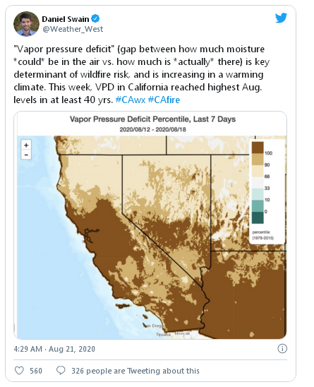
According to the paper, "Nearly all of the increase in summer forest-fire area during 1972–2018 was driven by increased vapor pressure deficit."
Midwest Derecho
A derecho is a particularly fierce and long-lasting line of thunderstorms, often causing winds over 75 mph. While these weather events are common during summer, the event that took place August 10 in Iowa and Illinois seemed otherworldly.
The squall line plowed a path 800 miles long and 40 miles wide through communities and corn fields, damaging 43% of Iowa's corn and soybean crop and causing nearly $4 billion in damage. Winds are estimated to have reached up to 140 mph, with hurricane-force winds lasting 40 to 50 minutes.
At first glance it would seem that this is just a freak natural event, with no real connection to climate change, but that may not be the case. While there is not much research on the connection between climate change and derechos, onerecent paper found some alarming results.
The research team used a climate model to simulate mesoscale convective systems (MCSs), a technical term for masses of thunderstorms, in a warming world. These MCSs are the parent structures which sometimes spawn derechos. Using a high greenhouse gas emissions scenario, the paper concluded: "At the end of the century, the number of intense MCSs are projected to more than triple in North America during summer due to more favorable environmental conditions."
The research also found that MCSs' maximum hourly precipitation rates will increase by 15% to 40% in the future, due to a warmer atmosphere loaded with more moisture. "The moisture source for MCSs in the central U.S. is predominantly the Gulf of Mexico and climate change will increase the low-level jet stream moisture transport from the Gulf northward," explains lead author Dr. Andreas Prein, from the National Center For Atmospheric Research.
"How this all relates to changes in derecho frequency and intensity is poorly understood," Prein admits, but now that climate models are capable of modeling this, he plans to make it a priority in future studies.
While Mann did not comment specifically on derechos, he does feel extreme events are not properly captured in current climate models. "I have argued that the climate models are likely underpredicting the impact on the frequency and severity of various types of extreme summer weather events due to deficiencies in their ability to capture some of the relevant jet stream dynamics."
Hurricane Season
Having two tropical systems like Marco and Laura in late August, the beginning of the peak of hurricane season, is not abnormal, even if the storms are very close to one another. But what is abnormal is the record-setting pace of the current hurricane season. So far the Atlantic season has tallied 14 named storms, 10 days ahead of record pace. That's two more than the average number for an entire season, which runs through the end of November. Seasonal forecasters are predicting up to 25 named systems this year, which would place second behind 2005.
While there are many factors that contribute to how active a hurricane season will be, the most obvious is the warm water which fuels storm development. This year, nearly the entire tropical Atlantic Basin is above normal. This is part of a long-term trend of warming in which Atlantic sea surface temperatures haveincreased by around 2 degrees Fahrenheit since 1900, and the measure ofOcean Heat Content hits record highs each and every year.
Warmer ocean temperatures do not guarantee more storms, but they do tip the balance, giving storms that extra boost to develop. After years of research, climate science is still not sure how a warming climate will impact the number of systems in the future, but there is consensus that, in general, hurricanes will get stronger and the strongest, most destructive hurricanes will get more frequent. Since major hurricanes — Category 3 and greater — are responsible for 85% of the damage, a warmer climate is likely to have devastating economic and human consequences.
Compound Events
Within research circles and among emergency planners, the concept ofcompound threats has become a very popular subject. For years now scientists have warned that increasing population, exposure and vulnerability combined with extreme events spiked by climate change, would overwhelm resources and compromise emergency response. Experts argue we are now seeing that unfold in real time.
"These equally profound events occurring in different parts of the country at the same time — what we call compounded or connected extremes — run the risk of putting significant strain on resources, budgets, and the supply chain," said Bowen.
This is a topic often missed in general discussions of climate change. It may seem easy to dismiss a few degree rise in global temperatures as inconsequential. However, when a cascade of extreme events, each made worse by human-caused climate change, pile on top of one another, it exposes the fragility of interconnected human systems.
"Add in the continued complications posed by COVID-19, and you're faced with even greater challenges in trying to get communities back on their feet," Bowen said.
Bowen recently authored a paper with other prominent scientists attempting to tackle this complicated issue. He says because of socioeconomic factors, population spreading into more high-risk regions, and an acceleration of climate change, more intense events "will only exacerbate the impacts of these compound scenarios in the future."
Experts warn that what we are witnessing in the present moment is a window into everyday life in the not-too-distant future if humans do not reverse course and curb emissions. This is how climate change becomes a truly destabilizing force. That's why Bowen and colleagues argue that much more urgency is needed to identify these unexpected combinations and the risks they pose to society.
This story originally appeared in CBS News and is republished here as part of Covering Climate Now, a global journalism collaboration strengthening coverage of the climate story.
26 August 2020
EcoWatch