How Nantucket Is Preparing for Rising Seas
The Massachusetts island anticipates damages of $3.4 billion through 2070 if nothing is done.
NANTUCKET—It’s no longer unusual to see a kayaker paddling along downtown Easy Street. The cobblestones along the town’s waterfront once were flooded a handful of times a year. That rose to an average of 37 days a year by 2020, according to tide gauge monitors by the National Oceanic and Atmospheric Administration.
The next year, Nantucket began taking steps to beat the tide.
Town and county officials cooperated on a coastal resilience plan in 2021 following an island-wide risk assessment that found four major concerns: groundwater table rise, coastal flooding, high tide flooding and coastal erosion. The 270-page report was more than timely: Easy Street was flooded a record 75 days in 2023.
Leah Hill, the town’s coastal resilience advisory coordinator, said in an email exchange that a smart defense is the best way for the island off Cape Cod to survive. The initial assessment found 2,373 buildings and structures at risk from erosion and flood in the next few decades. Of those buildings, 84 percent are residential and nearly 50 percent are historic, according to the assessment.
The resilience plan is simple in theory and challenging in execution, given the island’s mix, Hill said. It is based on three strategies. “Protect (keep water out), adapt (live with water), retreat (move away from water),” according to Hill’s email. “Depending on which critical infrastructure is at risk depends on which strategy is recommended.”
About 14,000 people live on the island year-round and the population soars to 80,000 during summer months, according to the 2020 census.
Nantucket’s Coastal Resilience Advisory Committee—made up of representatives from the Conservation Commission, the Land Bank and the town’s planning board among others—is the latest effort by a community that has been vigilant about protecting its coast and wetlands.
Hill said that the coastal resilience plan will assess risks every five to 10 years. The plan so far has identified 40 proposed projects over the next 15 years at a cost of $930 million—and Hill noted that if nothing is done to fight sea level rise, Nantucket anticipates damages totaling $3.4 billion through 2070.
To date, the island has committed to $14 million for coastal resilience projects, which includes planning, design and implementation.
Hill said about $2 million has been spent since 2020, including $350,000 on pond and road improvements and $500,000 to develop the coastal resilience plan. The town also applies for federal and state grants. In 2022, Nantucket received $158,000 in a SNEP Watershed Implementation Grant from the Environmental Protection Agency and another $500,000 from the state Office of Coastal Zone Management. Nantucket has allocated $2.5 million over the next few years for an Easy Street flood mitigation project and another $4.5 million for a pond/roadside protection project.
Dr. William Sweet is an oceanographer at NOAA, which has been tracking sea level rise in Nantucket Harbor since 1965. Sea levels have risen there by about half a foot since 2000, and this rate is accelerating, he said. Over 50 years, sea levels on Nantucket rose about eight inches, with six recorded since 1985, according to NOAA data.
Sweet said the sea level could rise a foot higher by 2055 based on the agency’s 2022 interagency report. Nantucket represents, he said, “more or less the East Coast story.”
Sweet said that NOAA assesses sea level rise every four years through an interagency task force that includes NASA, the EPA, the U.S. Geological Survey and the Defense Department and academics. Scientists look at possible future global temperatures and projected glacier melt to estimate scenarios, he said, and an important cycle affecting the tide range will peak for Nantucket in 2030. That could imperil day-to-day life.
“As sea levels have brought water closer to the brim in these communities, every inch matters,” he said.
Dr. Sarah Bois is the director of research and education for the nonprofit Linda Loring Nature Foundation, which operates from a wildlife preserve created over decades. Bois said that by modifying landscaping and natural spaces to better handle heavy and continued rain and rising waters, they are pursuing protections for homeowners, renters, businesses and the important tourist trade.
Pipes that carry stormwater are being assessed and patched this spring, and new fees to support repairs are being considered. Lily Pond Park is a 6.5-acre park with 4.9 acres of wetlands, for example, that requires careful restoration methods, said Emily Goldstein Murphy, director of environmental and agricultural resources at the Nantucket Land Bank. The engineering firm Horsley Witten Group has been contracted for the two-year project and a $600,000 federal grant will help with the $5.5 million cost, she said.
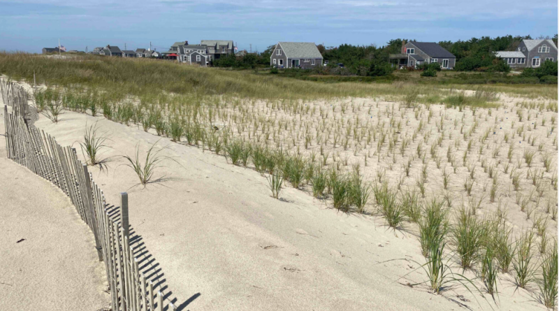
Among the improvements in Nantucket: dune restoration has stabilized an area near Millie’s Bridge in Madaket that has been battered by winter storms. Rain gardens on Easton Street in Brant Point have been designed to filter stormwater runoff before the water flows toward the harbor. Bioswales, low-lying troughs of grass and plant materials, absorb and manage stormwater. They have been incorporated in various projects throughout the island including the Easton Street rain gardens and are also being considered for the Lily Pond Park project. Discarded oyster shells have been repurposed at Polpis Harbor Oyster Reef to restore a salt marsh and preserve the habitat for native sparrows.
Dr. Jennifer Karberg, director of research and partnerships at the Nantucket Conservation Foundation, which owns over 9,000 acres of land and coastal shoreline on the island, said the nonprofit has years of experience of living with nature’s demands. Climate change requires more specificity. “What’s the resiliency of an area?” Karberg asked. “We’re doing a lot of work to understand what our baseline salt marsh health is.”
Karberg said land management is critical. The Nantucket Conservation Foundation owns about a third of the island’s land and monitors ongoing changes in pollinators, precipitation, drought, forest management and invasive plants and species.
The foundation is currently halfway through a project to restore the Windswept Cranberry Bog into a natural wetland, she said. The bog was retired and taken from commercial use in 2018 in part due to climate change’s effect on the cranberry industry in southeastern Massachusetts.
Both Karberg and Bois led discussions at the Nantucket Climate Change summits in 2023 and 2024 where business owners, conservationists and board members from the historical society spoke about their hopes and fears about the change. Bois said the resiliency plan is preparing for a moving target.
“It’s not like we create the coastal resilience plan, and then we follow it, and we’re done,” Bois said. “It’s because the change is continuous, and we can’t anticipate all the different ways that the community is going to be impacted. It is something that we have to kind of revisit and think about and adapt as it goes along.”
A concern for everyone is the future of the ferry and specifically, the dock in Nantucket. It is a lifeline to the outside world and vulnerable to floods. Claire Martin is the executive director for Envision Resilience, an initiative created by the nonprofit Remain, which continues to look for ways to protect that transportation hub.
Since 2021, Envision Resilience has worked with almost 500 students on programs to address conservation. During the first year of the program, Envision Resilience was based in Nantucket and focused on three locations in town: Brant Point, downtown and Washington Street. Students enrolled in the Envision course receive college credit and mentoring from foundation advisors.
Students are encouraged to think creatively about Nantucket’s future, somewhere between conservative plans and wishful thinking, Martin said.
“Somewhere in the middle is where we’ll need to get to,” she said. The goal is to “become more adaptive as a community, as a waterfront, so that we can kind of learn to mitigate and live with the water, rather than run away from it.”
Cover photo: Dune restoration has stabilized an area separating Hither Creek from the Atlantic Ocean in Madaket, Nantucket. Credit: Jennifer Karberg/Nantucket Conservation Foundation