The floods and droughts devastating Australia are fingerprints of a warming planet

It is undoubtedly clear that continuing to burn or export fossil fuels will increase climate change and the risk of extreme weather
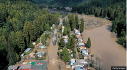
As New South Wales once again faces heavy rainfall and flooding, the Victorian towns of Euroa and Violet Town will enter stage 2 water restrictions next Wednesday. How is the climate crisis affecting these contrasting extremes?
The weather pattern bringing heavy rainfall to NSW is a common wet-weather scenario for the coast. A high-pressure system in the Tasman Sea has stalled, and the anticlockwise air flow around the high is pushing moist air from the ocean over land. At the same time, about three kilometres above the surface, a low-pressure system is lifting the moist ocean air up. As moist air rises, it forms clouds, storms, and finally rain.
While this weather pattern itself isn’t unusual, the duration of the weather pattern is. Typically, high pressure in the Tasman may hang around for one to two days. But the current high has been there for the past four days, bringing unrelenting rainfall to NSW. The rain is falling on already sodden ground, increasing the likelihood of flooding.
This is reminiscent of what we saw during the March 2021 floods. Unfortunately, the forecast for the next few days is also reminiscent of March 2021. After the rain from the east finally moves away, another strong band of rain is forecast to cross NSW from the west on Monday.
Scientists are actively researching how climate change is shaping Australia’s weather systems. We are not sure if weather systems will stall more often or not, mostly because we don’t yet have the computing power to run high-definition climate models needed to study them.
However, climate modelling capability is growing every year. Just last week, Australian climate scientists took part in a global hackathon to analyse data produced by models with about 50 times higher resolution than a typical one. Earlier studies using lower definition models suggest we may see a decrease in stalled high pressure in the Tasman Sea, and low-pressure systems may also occur less often but produce more intense rainfall when they do happen.
While future high- and low-pressure systems are uncertain, atmospheric moisture is likely to increase in a warmer world.
After the March 2021 floods, my colleagues and I assessed how often Sydney may experience persistently high amounts of atmospheric moisture over the region. High atmospheric moisture is a key ingredient in heavy rainfall, and when it sticks around for a while, persistent rainfall and flooding become more likely.
We found that by 2080-2100, the chance of these high moisture events may increase by about 80% under both moderate and high emissions scenarios. With more moisture in the atmosphere, when low-pressure systems do occur and help convert the moisture into rain, the rain will probably be more intense due to global heating.
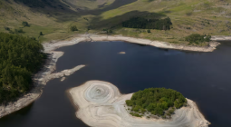
As NSW sandbags, Adelaide is ramping up its desalination plant to ensure the city’s water supply. Parts of South Australia, Victoria, Tasmania and Western Australia have received very much below the average rainfall over summer and autumn. Drought in Australia is largely driven by a lack of heavy rainfall events. Only one to five days of heavy rainfall per year can be the difference between whether there is a drought or not.
The climate patterns in the Indian and Pacific Oceans, which influence year-to-year rainfall variability in Australia, have been in neutral or dry phases. Neither El Niño nor La Niña have appeared since autumn 2024. La Niña tried to rear its head over summer but didn’t quite develop.
The visually spectacular northwest cloudband, which can bring a band of rainfall from Broome to Hobart, has been absent this year. Instead, slow-moving high-pressure systems have brought frustratingly settled weather to southern Australia.
Like flooding, the change in drought occurrence with a warming planet is still a leading topic of research in Australia. Since droughts are rare events, identifying trends in the data is much harder than identifying trends in maximum temperature, for example, which happens every day.
The “tinderbox drought” of 2017-2019 was the first drought in Australia where the severity would not have been possible without global heating. Additionally, southwest Australia has seen a robust rainfall decline since the 1970s, which is expected to continue.
Droughts and floods have marked the Australian psyche for generations. But the fingerprints of a warming planet are starting to appear as increasing rainfall intensity and drought severity. It is undoubtedly clear that continuing to burn or export fossil fuels will increase the risk of extreme weather devastating Australia.
Cover photo: As NSW faces flooding again, Victorian towns enter stage 2 water restrictions. A woman and her dogs pictured paddling past an SES flooding sign on Friday. Photograph: Renee Moore/AAP