One of Britain’s largest sunken forests reveals its secrets
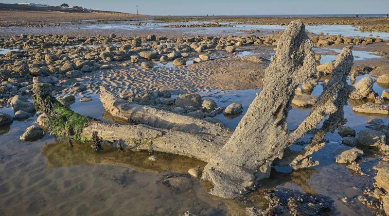
On a broad expanse of beach overlooked by towering cliffs on the UK’s south coast, a ghost forest can be glimpsed at low tide. Easily missed among the boulders and rock pools, a landscape of gnarled black stumps and enormous fallen tree trunks is revealed and submerged twice a day in a bay between Hastings and Rye.
Twisted and smoothed by the tides, the soggy wood is strewn with barnacles and peppered with thousands of holes made by piddocks – burrowing shellfish which have made the logs their home.
But this is not just driftwood. These are ancient trees, their stumps still rooted to the spot where they died due to rising sea levels up to 6,500 years ago.
The site, at Pett Level in Rye Bay, East Sussex, is one of the UK’s largest sunken forests and would have once formed an extensive area of coastal woodland stretching more than five miles to the east to Rye Harbour and about eight miles to the west, towards Bexhill.
Just yards from the witchy burls and branches of the sunken forest, fossilised dinosaur footprints made by iguanodons and ankylosaurus up to 100m years ago can be found in boulders that have fallen from the crumbling cliffs.
Today, a tall embankment holds back the sea waters from the acres of reclaimed land that make up Pett Level. But over the millennia, the rising waters that made an island of Britain and a sea out of the river valley that became the Channel, also rose high enough to swamp the forest, killing the trees.
Once scarcely studied, the sunken forest is now yielding its secrets to scientists examining how climate breakdown at the end of the last ice age radically altered landscapes and environments as sea levels rose and the climate warmed.
Dr Scott Timpany, a paleoecologist at the University of the Highlands and Islands and an expert on sunken forests around Britain, says the ancient wood contained substantial numbers of oak trees at certain points in its history, as well as elm, beech and yew.
“These would have been wet woodlands – not like a park woodland. This would have been a pretty boggy, wet environment with pools of water on the surface in places. This would likely have been getting wetter as sea levels rose, as glaciers melted, raising the groundwater table.
“The woodland remains we see today are from lots of different periods of time,” he adds. “On the surface of the intertidal zone at the moment, you’ve got oak trees that date from the late Mesolithic all the way through to oak, elm and ash from the middle bronze age.
“As you go down the beach you’re effectively stepping back in time.”
As recently as 1850, historian William Durrant Cooper wrote that the sunken remains of “Dymsdale Forest” – as it was once known – can only be seen “at low water, during spring tides”.
Less than 200 years later, no spring tides are required to see what remains of the woodland. Visitors can wander down to the beach at low tide and poke at the spongy tree trunks, which fell long before Stonehenge or the Giza pyramids were built.
As well as the ravages of winter storms, rising sea levels and the interplay of three rivers coming together in Rye, the coast is moulded by longshore drift – the relentless eastwards flow of shingle, the pebbles that define the beaches of much of Britain’s south coast.
This is of particular concern to commercial shipping at Rye Harbour. Large container vessels navigate a narrow channel at the mouth of the River Rother, the opening of which would be rapidly blocked by the flow of shingle if left unchecked. Any buildup would also have serious consequences for the reclaimed land at Pett Level, Romney Marsh and the area immediately around Rye.
To address this, a concrete arm protecting the entrance to the harbour traps the shingle, and a fleet of tipper trucks remove up to 80,000 tonnes of the pebbles every year, transporting them five miles west to protect the sea wall at Pett Level, in a perpetual battle between the forces of nature and the Environment Agency.
“I would estimate that without this effort, within three years the sea would be punching a hole through the sea wall, and all of Pett Level would become saltmarsh,” says Barry Yates, former manager of Rye Harbour nature reserve.
The effects of human activity on longshore drift continue to play a significant role in how the coastline changes, and may be a key reason why the sunken forest has become so exposed in recent decades.
The creation of a concrete harbour arm in Hastings in the early 20th century cut off much of the eastward flow of shingle. In turn, this reduced the volume of shingle covering the base of the cliffs between Hastings and Pett Level, thereby exposing the cliffs to the sea and increasing the rate of erosion.
Yates says: “The cliffs are marching inland as they erode, and it’s the base of the cliffs which dictate where the root of the developing shingle ridge starts. Over time, the cliff has been eaten away, so the starting point of the shingle ridge east of the cliffs has moved northwards and that uncovers all of the peat and the old trees that are there.”
Maps of the coastline here at different points over the past few centuries clearly show that whole towns, such as Old Winchelsea, have been lost, and how rivers have substantially rerouted themselves.
“We have this sense that everything’s here for ever, but it’s not at all,” says local author Gareth E Rees, whose forthcoming book, Sunken Lands, explores humanity’s long relationship with cataclysmic climate breakdown.
“When we look at the sunken forest – at this incredible thing that existed and was powerful, full of life and ancestors and animals and hunters, it disappeared. It’s gone,” says Rees. “We’re also going to have to let things go. There’s a false security in building more and more dykes and barriers. You can’t keep adding engineering solutions.”
Yates agrees. “Although we have kept things in place for now by carting shingle up and down, inevitably, the sea and the elements are going to have their way. This bit of coast should be mobile, and the plants and animals have ways of coping with that.”
But he says the shifting coastline also serves as a warning. “Most of the ice from the last glaciation has melted, but the last bit that still exists is going to have a huge impact. Most people in the world live at low sea level. We just aren’t awake to that.
“I don’t know what it is going to take for people to realise what needs to be done.”
cover photo:Ancient stumps and logs rise out of the sand in front of the cliffs at Pett Level in East Sussex. Photograph: www.mjt.photography/Alamy