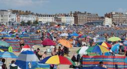
UK temperatures pass 34C for six days in row for first time since 1961.
Heatwave continues to cause disruption as flooding and storm warnings issued.
The UK has had its longest stretch of temperatures exceeding 34C since the 1960s, as warnings of thunderstorms and heavy rain remain in place across the country.
The Met Office said the scorching temperatures were recorded in parts of southern England for the sixth day in a row – the first time Britain has experienced such a spell since 1961.
A thunderstorm warning for much of Wales, the West Midlands and parts of the north-west was upgraded to amber on Wednesday evening after severe storms caused disruption in some areas.
The Met Office warned that flooding, damage to buildings, travel disruptions and power cuts are to be expected, as well as 30 to 40mm (1.1in to 1.6in) of rainfall in less than an hour in some places.
Meanwhile, a yellow thunderstorm warning covers much of England and Wales owing to unsettled conditions caused by the current heatwave. It comes as water firms advised customers in certain areas to restrict their usage in the sweltering conditions.
Thames Water urged customers to use water for essential purposes only in the coming days, while Essex and Suffolk Water said that because of “record water demand” it was working to maintain supplies but users could notice lower than normal pressure.
Temperatures reached 34.6C in St James’s park in central London on Wednesday, marking the first time since at least 1961 that there have been six consecutive days of 34C and above.
It was also the third day in a row of the mercury hitting 35C or above across the UK, with Wednesday’s highest temperature of 35.4C recorded at Heathrow, according to the Met Office.
Forecaster Greg Dewhurst told PA Media: “It’s not often we get temperatures this high over several days, and that is triggering thunderstorms across parts of England and Wales.
“If rain is falling on places that have been quite hot and dry, and the ground is quite hard, the rain doesn’t have anywhere to go, and from that we can see flash flooding.”
Gloucestershire Fire & Rescue Service said it was experiencing “high call volumes” due to bad weather and had been made aware of flash flooding in Gloucester on Wednesday evening.
“Whilst the bad weather continues, please be careful and only travel if absolutely necessary and with extreme caution,” it tweeted.
Elsewhere, Cheshire police said on Twitter they were dealing with a number of weather-related incidents in the village of Tarporley, including fallen trees and flash flooding, and advised nearby residents to avoid all but essential travel.
Some 10 flood alerts covering areas in the West Midlands were issued by the Environment Agency on Wednesday evening, while three flood warnings were in place – meaning immediate action is required.
Two of the warnings, which indicate flooding is expected, cover the River Trent, while third was issued for Sandyford Brook in Stafford.
Severe storms could cause 30 to 40mm of rain to fall in less than an hour in some places, which would follow the heavy downpours that lashed large parts of Scotland and caused flooding on Tuesday evening.
Three people died in a train derailment near Stonehaven in Aberdeenshireafter a ScotRail service crashed on Wednesday after heavy rain and flooding. The train’s driver and conductor and a passenger were killed and six people were injured.
Perth and Kinross, the Lothians, Forth Valley and the north-east were among the most affected by overnight lightning strikes and heavy rain.
The Scottish Fire and Rescue Service confirmed it was called to multiple reports of flooding in the Perthshire area, affecting many properties.
Vehicles were recovered from busy roads after they were abandoned and there were reports of internet services being disrupted.
Thunderstorms are expected to clear overnight, while temperatures could remain above 20C for “warm and humid” conditions, according to Dewhurst.
“Parts of the UK will see some very heavy thunderstorms with torrential rainfall and a chance of flash flooding from Wednesday, this could result in landslides and problems with travel,” added Met Office forecaster Bonnie Diamond.
“Yellow thunderstorm warnings will remain in place until Sunday, affecting most of the UK.”
Similar conditions were expected to be seen in parts of Northern Ireland, England and Wales from Wednesday afternoon, with drivers warned of delays on the roads caused by standing water.
Police forces and the RNLI have warned about the dangers of entering water after the heatwave led to a number of weather-related accidents across the country over the past week.
Following a grey start to Thursday, there will be sunny spells across much of the country with maximum temperatures of up to 32C in the south-east of England.
“It’s still going to be warm and humid and that could then trigger some thunderstorms across parts of England and Wales through the afternoon and evening tomorrow,” Dewhurst said.
A yellow thunderstorm warning which covers the majority of England, excluding parts of the north-east, has been issued by the Met Office for Thursday.
Further unsettled weather is predicted throughout the afternoon and evening. Dewhurst added: “Generally, the rest of the week remains unsettled with showers, some of them thundery and heavy, but there will still be some warm, sunny spells at times too.”
12 August 2020
The Guardian